Vancouver, British Columbia – Ero Copper Corp. (the “Company”) (TSX: ERO) is pleased to provide a quarterly update on the ongoing exploration drill programs on its 99.6% owned Vale do Curaçá Property located in Bahia State, Brazil and its 97.6% owned NX Gold Mine located in Mata Grosso State, Brazil. This update encompasses drill results received from December 2019 through March, 2020. Drilling during the period continued to focus on priority target areas within the Pilar Mine, Vermelhos Mine, the broader Curaçá Valley as well as extensions of the Santo Antonio Vein at the NX Gold Mine, all according to the planned drill programs for the first quarter of 2020, which have not been impacted by the COVID-19 pandemic.
HIGHLIGHTS
- Continued success in demonstrating continuity of the high-grade ‘Superpod’ mineralization below the known extent of the Pilar Mine within the “Deepening Extension” zone, highlighted by:
- FC47163: 22.8 meters grading 3.18% copper including 10.6 meters grading 5.29% copper;
- FC5623: 21.8 meters grading 2.27% copper including 2.8 meters grading 7.76% copper, drilled approximately 400 meters north of hole FC47163; and,
- mineralized intercepts within the Deepening Extension now extend over approximately 800 meters in strike length and to depth over 400 meters below the current level of the primary ramp. The zone remains open to the north and to depth.
- Extended the known limits of the Vermelhos Mine orebodies from the initial results of a systematic fan drill program surrounding the main orebodies of Toboggan and Sombrero, including to depth, highlighted by:
- FVS-709: 7.6 meters grading 11.48% copper including 4.6 meters grading 17.39% copper, located approximately 10 meters east of Toboggan;
- FVS-585: 10.0 meters grading 2.98% copper including 3.4 meters grading 4.79% copper located approximately 20 meters east of Toboggan; and,
- FVS-638: 7.2 meters grading 2.16% copper including 2.0 meters grading 4.62% copper and hole FVS-634: 2.5 meters grading 3.52% copper, located approximately 96 meters and 125 meters beneath the main Vermelhos orebodies, respectively, making them the deepest known intercepts beneath the Vermelhos main orebodies to date. Additional drilling is planned to further define the size and extent of these newly intercepted lenses at depth.
- Extended the known limits of mineralization within the Siriema deposit by an additional 400 meters beneath the current inferred mineral resource limit with wide-spaced, down-plunge, 200 meter step-out exploration drilling resulting in a series of deeper intercepts, highlighted by:
- FSI-89: 6.0 meters grading 2.21% copper including 3.0 meters grading 3.12% copper, located approximately 400 meters down-plunge of the current mineral resource along a north-plunging structural conduit that can be traced to the Keel Zone. Drilling remains focused on following the structural conduit to the north and to depth to further evaluate potential for a wider zone of mineralization and the potential for additional copper-nickel and platinum group metal (“PGM”) zonation first observed within the Keel Zone of the Siriema deposit.
- At the NX Gold Mine, continued success in programs focused on upgrading the current inferred mineral resource and testing down-plunge extensions of the high-grade mineralization of the Santo Antonio vein. Results are highlighted by:
- SA69: 3.8 meters grading 19.22 grams per tonne gold drilled at the limit of the current inferred mineral resource; and
- SA73: 4.9 meters grading 10.21 grams per tonne gold, hole SA70: 4.9 meters grading 9.53 grams per tonne gold and SA76: 3.5 meters grading 2.24 grams per tonne, located approximately 30 meters, 45 meters and 125 meters down-plunge from the limits of the current mineral resource (and hole SA69), respectively. The Santo Antonio vein remains open to depth.
- Regional work comprised of both exploration drilling and ground-based geophysical work is currently focused on four newly interpreted mineral systems within the portfolio of targets defined by the Company’s comprehensive targeting work. Each of the new systems has an average strike length of 5 kilometers and contain multiple priority drill targets. While preliminary results are encouraging, additional detail on these ongoing exploration programs is expected during the second half of the year.
Commenting on the results, David Strang, President & CEO, stated, “At the outset of 2020 we set ourselves several objectives with this years’ exploration program. The first and foremost objective was to demonstrate continuity of high-grade mineralization within the Deepening Extension zone of the Pilar Mine. We believe successful execution of this program, as demonstrated in this first quarter update, continues to have the potential to meaningfully contribute to securing the future production profile of the Company and be instrumental in maintaining an elevated grade profile in the years to come. Similarly, the results from resource upgrade and extensional exploration programs at the NX Gold Mine give us comfort that we will be able to continue to add significantly to mine life and secure the future of the mine.
While the onset of the COVID-19 pandemic has not impacted our planned exploration programs, the closure of many third-party laboratories has limited our ability over the near-term to analyze for cobalt, gold and PGMs (although we are currently building this capability in-house). Despite these pending assays, I am pleased to say that we have made significant strides during the first quarter in extending mineralization across each of the assets within our portfolio. In addition to the successes at Pilar and at the NX Gold Mine, notable extensions of the Siriema controlling structure to depth and the preliminary, but exciting, results from the systematic Vermelhos Mine fan drilling speak to the successes our exploration teams are having throughout our organization.
As we look forward to the balance of the year, and a progression to more regional drilling, we see the emergence of four key regional mineralized systems on which we are focusing our exploration efforts in the near to medium term. By year-end, we continue to expect the majority of our total meterage drilled will be allocated to a selection of targets within these systems.”
Twenty-six drill rigs are currently operating in the Curaçá Valley, including twelve within the Pilar District, eleven in the Vermelhos District, and there are currently seven drill rigs (including four within the Vermelhos District) operating on regional exploration targets in the Curaçá Valley. Five additional drill rigs are currently operating at the NX Gold Mine.
Expansions and extensions, as referenced herein, reflect mineralization not captured in the Company’s mineral resource and mineral reserve models used in the current (2019) mineral resource and reserve estimate. There has been insufficient work and analysis surrounding new discoveries, as referenced herein, to define a mineral resource and it is uncertain if further exploration and analysis will result in such targets being delineated as a mineral resource.
The drill holes outlined in this press release within the Vermelhos and Pilar Districts will be made available on the Company’s Curaçá Valley site tour and interactive three-dimensional models for the Pilar Mine and the Vermelhos System, which can be accessed via the Company’s website (www.erocopper.com) or via VRIFY Technology Inc. (“VRIFY”) (www.vrify.com).
PILAR DISTRICT
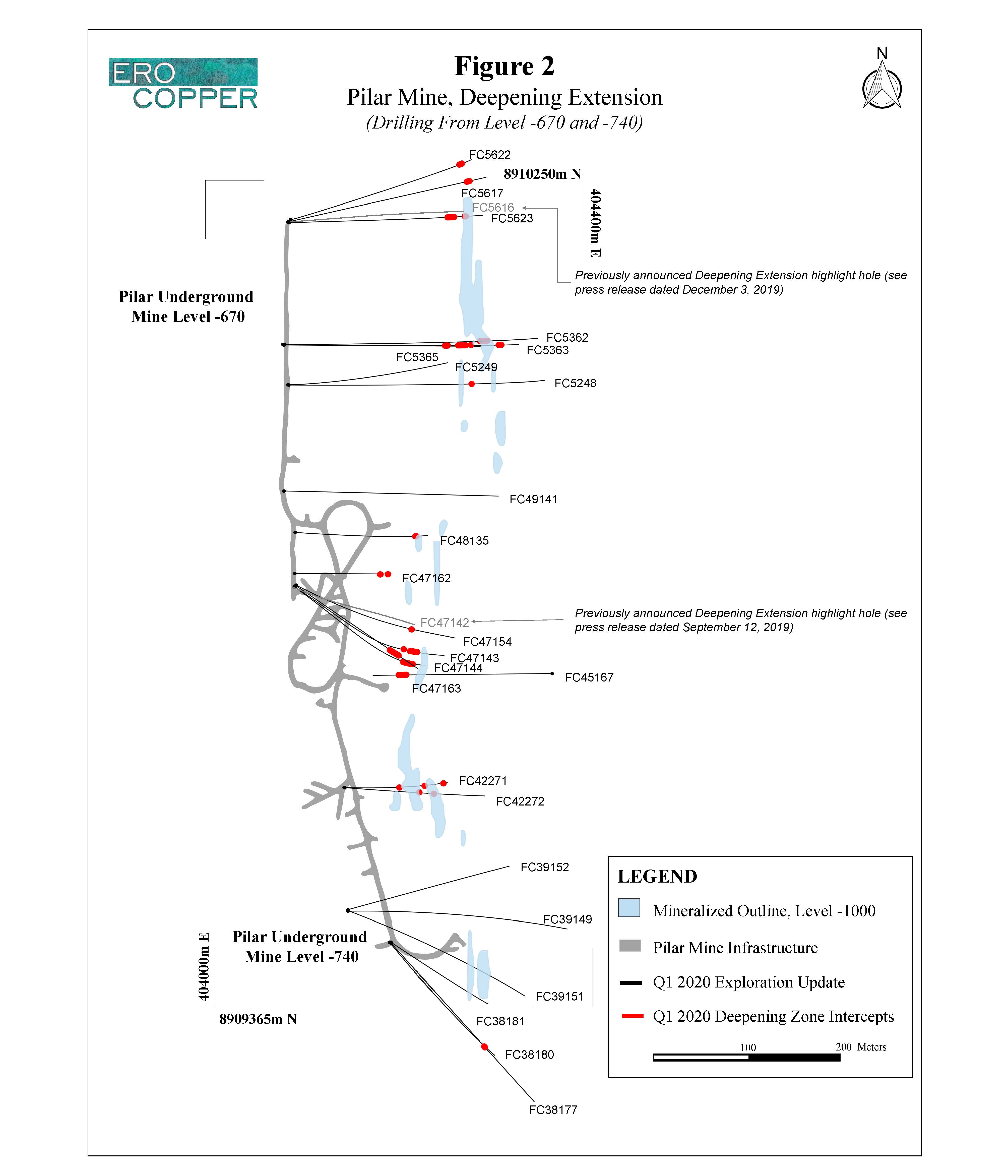
The Pilar District encompasses the area surrounding the Pilar underground mine, Caraíba Mill complex and the past producing Pilar open pit and R22 Mines. Twelve drill rigs are currently focused on resource upgrade and exploration programs within the Pilar Mine.
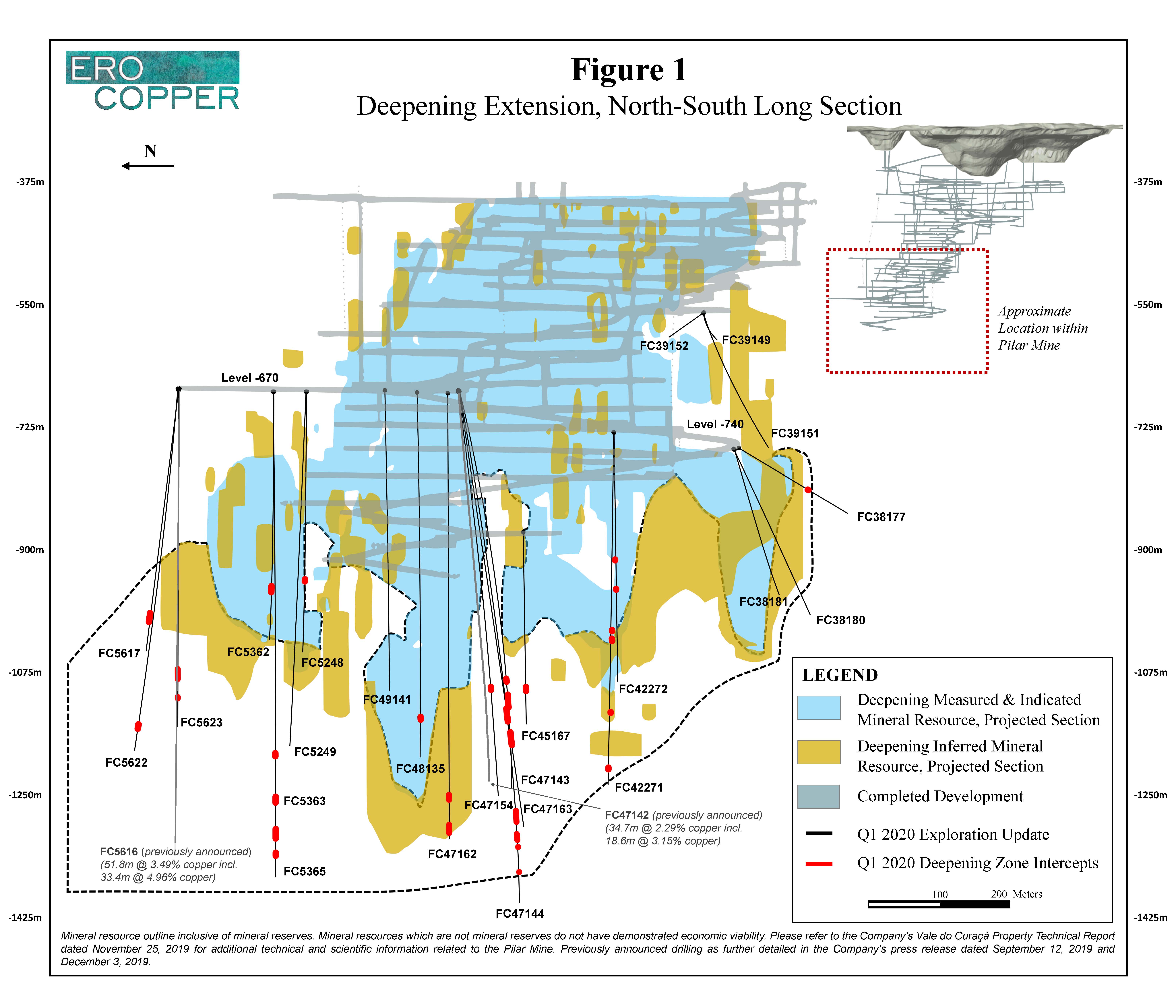
During the period, the Company has continued to prioritize drilling of the Deepening Extension where the Company continues to confirm thick and high-grade mineralization of a recently identified mineralized chamber, or “Superpod”, within the Deepening Extension zone.
The Deepening Extension
Deepening Extension drilling is currently targeting mineralization on the East Limb of the Pilar Mine between level -725 and level -1300 approximately 1,200 meters to 1,750 meters below surface and approximately 100 meters laterally from the current level of the primary ramp (completed to level -935). Drilling in the Deepening Extension zone continues to extend the known limits of high-grade copper mineralization of the mine and intercept some of the most significant holes on a grade-meter basis drilled in the Pilar Mine since acquisition of the Vale do Curaçá Property in 2016, confirming continuity within a high-grade, mineralized chamber, or “Superpod”.
The Company has now identified a mineralized area within the Deepening Extension zone that extends over approximately 800 meters in strike length, over a total depth of approximately 400 meters and over an average thickness of approximately 15 to 20 meters with localized thicknesses of up to 50 meters. Within the total strike length, a higher-grade continuous zone with a strike-length of approximately 400 to 500 meters is emerging in the central and northern segments of the target area. The zone remains open to the north and to depth. There are currently five underground exploration drill rigs systematically drilling the defined exploration target area within the Deepening Extension zone.
New results during the period are highlighted by notable confirmatory and extensional drilling within the high-grade target area. In the central portion of the Deepening Extension, on section 47, new results are highlighted by hole FC47163 that intersected 22.8 meters grading 3.18% copper including 10.6 meters grading 5.29% copper and hole FC47143 that intersected 37.0 meters grading 1.49% copper including 5.0 meters grading 2.92% copper. Drill results in the central portion of the Deepening Extension are complemented by previously announced intercepts, also on section 47, in hole FC47142 that intersected 34.7 meters grading 2.29% copper including 18.6 meters grading 3.15% copper and hole FC47139 that intersected 7.1 meters grading 6.50% copper including 4.1 meters grading 9.01% copper. In the northern section of the target area, located approximately 400 meters north of the intercepts noted previously on section 47, new results are highlighted by hole FC5623 that intersected 21.8 meters grading 2.27% copper including 2.8 meters grading 7.76% copper which is complemented by previously released intercepts, also on section 56, in hole FC5616 that intersected 51.8 meters grading 3.49% copper including 33.4 meters grading 4.96% copper and hole FC5615 that intersected 62.5 meters grading 1.65% copper including 26.1 meters grading 2.37% copper (please refer to the Company’s press releases dated September 12, 2019 and December 3, 2019 for previously announced Deepening Extension results).
Exploration results from the Deepening Extension supports that the Pilar Mine remains open to depth, where high-grade mineralization continues to be encountered, based on the deepest intercept in newly drilled hole FC47144, approximately 420 meters below the deepest level of current development at the mine.
Please see Figure 1 for a north-south long section and Figure 2 for a level map showing collar locations of Deepening Extension drilling within the Pilar Mine.
| Hole ID | From (m) | To (m) | Length (m) | Cu (%) |
|---|---|---|---|---|
FC38177 | 164.5 | 168.0 | 3.5 | 0.77 |
FC38180 | NSI | NSI | NSI | NSI |
FC38181 | NSI | NSI | NSI | NSI |
FC39149 | NSI | NSI | NSI | NSI |
FC39151 | NSI | NSI | NSI | NSI |
FC39152 | NSI | NSI | NSI | NSI |
FC42271 | 294.1 | 298.5 | 4.4 | 1.32 |
and | 413.2 | 418.2 | 5.0 | 0.89 |
and | 496.2 | 500.2 | 4.0 | 1.57 |
FC42272 | 206.4 | 209.7 | 3.3 | 5.73 |
and | 249.9 | 253.4 | 3.5 | 1.15 |
FC45167 | 267.2 | 277.9 | 10.7 | 3.45 |
including | 272.8 | 275.9 | 3.1 | 8.11 |
FC47143 | 426.0 | 430.0 | 4.0 | 1.17 |
and | 449.0 | 486.0 | 37.0 | 1.49 |
including | 474.0 | 479.0 | 5.0 | 2.92 |
FC47144 | 607.4 | 627.2 | 19.8 | 1.41 |
including | 616.4 | 618.4 | 2.0 | 3.27 |
and | 638.5 | 654.5 | 16.0 | 1.71 |
including | 638.5 | 641.5 | 3.0 | 2.32 |
and | 659.5 | 663.5 | 4.0 | 0.95 |
and | 695.5 | 698.5 | 3.0 | 1.38 |
FC47154 | 435.8 | 441.9 | 6.1 | 1.24 |
including | 435.8 | 437.8 | 2.0 | 2.22 |
FC47162 | 573.2 | 585.9 | 12.7 | 3.27 |
including | 575.9 | 580.9 | 5.0 | 5.17 |
and | 617.9 | 622.0 | 4.1 | 2.70 |
and | 626.5 | 634.5 | 8.0 | 1.91 |
FC47163 | 465.5 | 488.3 | 22.8 | 3.18 |
including | 465.5 | 476.1 | 10.6 | 5.29 |
and | 499.3 | 523.5 | 24.2 | 1.33 |
including | 512.3 | 515.5 | 3.2 | 2.05 |
FC48135 | 476.2 | 479.6 | 3.3 | 3.36 |
FC49141 | NSI | NSI | NSI | NSI |
FC5248 | 328.74 | 333.2 | 4.5 | 1.22 |
FC5249 | NSI | NSI | NSI | NSI |
FC5362 | 346.3 | 359.2 | 12.9 | 1.35 |
including | 346.3 | 350.3 | 4.0 | 2.39 |
FC5363 | 560.8 | 570.8 | 10.0 | 0.83 |
FC5365 | 597.2 | 612.2 | 15.0 | 0.96 |
and | 604.2 | 607.2 | 3.0 | 1.47 |
and | 646.8 | 665.9 | 19.1 | 1.54 |
including | 646.8 | 649.8 | 3.0 | 3.00 |
and | 682.0 | 692.0 | 10.0 | 0.96 |
FC5617 | 373.7 | 382.7 | 9.0 | 1.00 |
FC5622 | 510.0 | 520.0 | 10.0 | 1.17 |
including | 510.0 | 512.0 | 2.0 | 2.26 |
FC5623 | 427.2 | 449.0 | 21.8 | 2.27 |
including | 445.2 | 448.0 | 2.8 | 7.76 |
and | 473.2 | 476.2 | 3.0 | 2.17 |
NSI indicates no significant intercept based on a three meter mining width and cut-off grade of 0.68% copper. Drill holes were drilled from level -670, level -740 and level -875 in the Pilar Mine. Holes not included are either pending assay results, have been included in a different section of this press release for clarity of discussing drill results or were previously included in a prior press release. The length of intercept may not represent the true width of mineralization. Values may not add up due to rounding. From, to and mineralized intercepts are rounded to the nearest tenth of a meter.
VERMELHOS DISTRICT
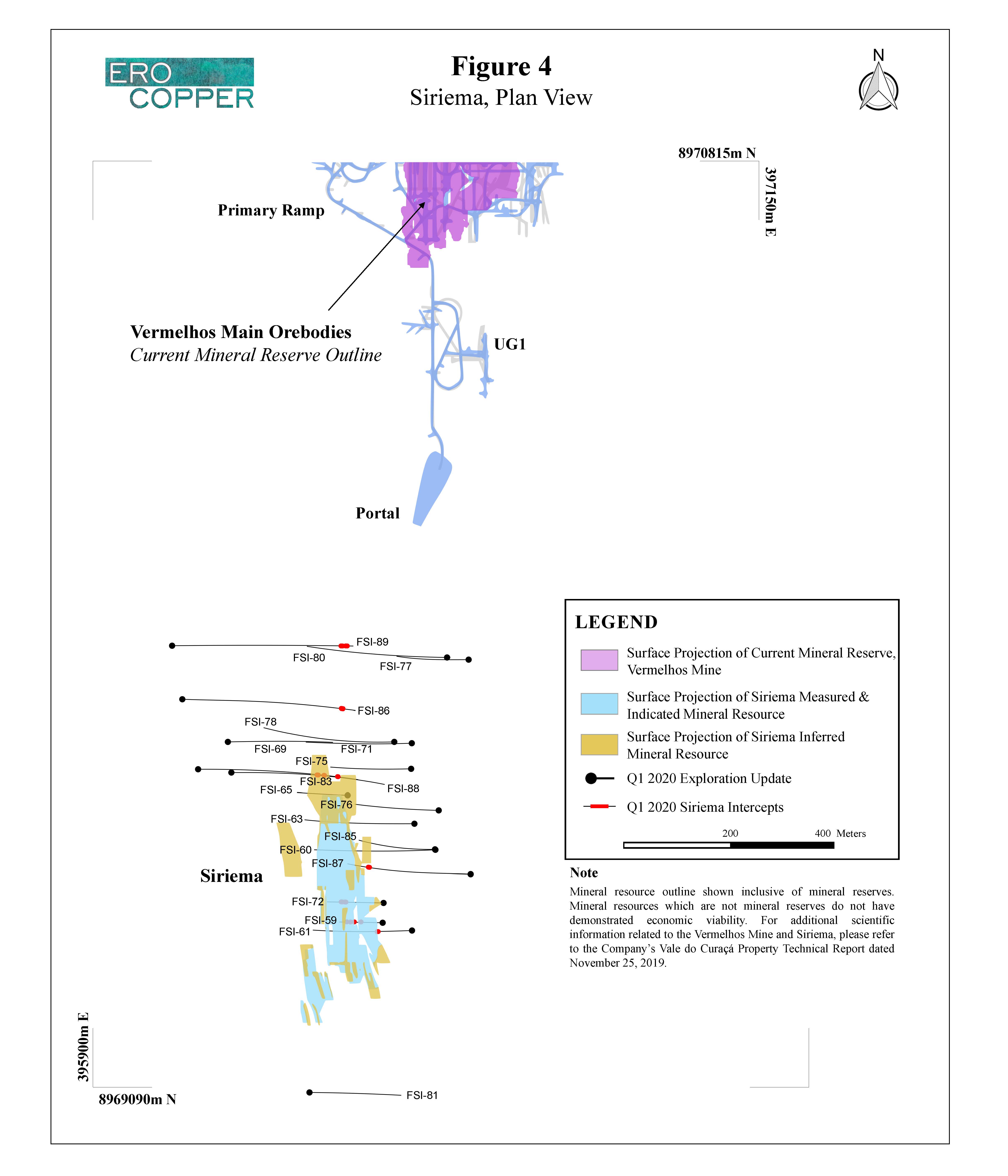
The Vermelhos District is located approximately eighty kilometers to the north of the Pilar Mine and Caraíba Mill complex and includes the operating high-grade Vermelhos Mine. Drilling is focused on both near-mine extensional drilling as well as new regional targets identified during the Company’s regional airborne survey and subsequent data compilation work of the broader Vermelhos System – a north-south trend encompassing the Vermelhos Mine, East Zone, Siriema N8/N9 deposit, and several high priority targets that extends over ten kilometers in strike length.
Eleven drill rigs are currently operating in the district including seven focused on upgrade and exploration programs within and adjacent to the Vermelhos Mine, including the Siriema deposit, while four rigs are focused on regional targets within Vermelhos System trend.
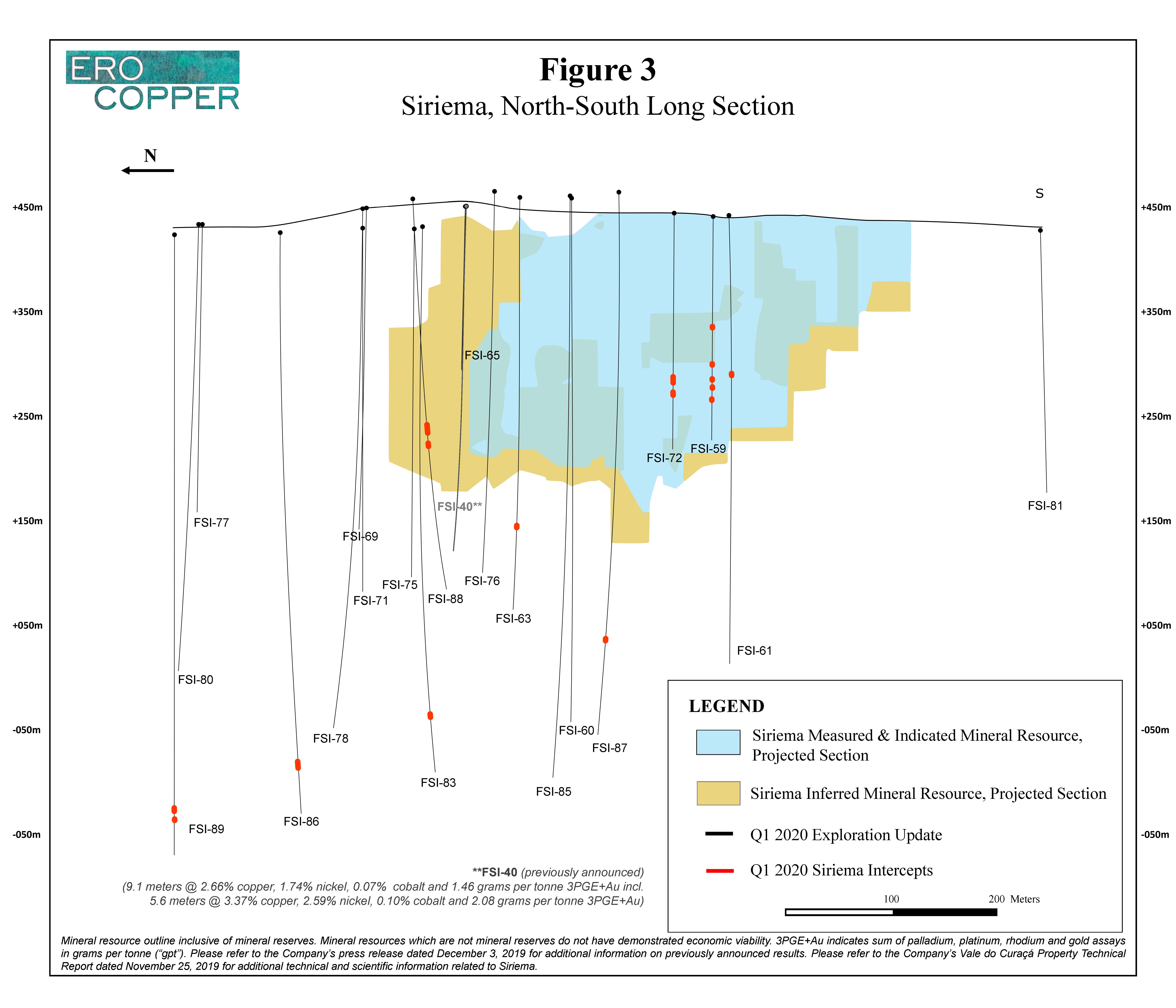
Siriema
The Siriema deposit is the Company’s first regional discovery (see press release dated July 30, 2019 for the announcement of the Siriema discovery) and is located approximately 1.5 kilometers south of the Vermelhos Mine. The exploration drill program at Siriema is focused on continuing to understand the relationship between the previously identified Keel Zone – a massive sulphide breccia zone of elevated copper, nickel, cobalt and PGMs within the Siriema deposit – and a north-plunging mineralized controlling structure, or conduit, and the potential for larger zones of copper, nickel and PGM massive sulphide mineralization down-plunge of the Keel Zone along the conduit (please refer to the Company’s press release dated December 3, 2019 for previously released multi-element intercepts).
During the period, wide-spaced, down-plunge, 200 meter step-out exploration drilling at Siriema has continued to intercept the controlling mineralized Siriema conduit at depth. To date, the Siriema conduit has now been encountered from surface to a depth of approximately 550 meters below surface and over variable thicknesses from sub 1 meter up to 20 meters. Siriema remains open to depth and to the north where drilling and down-hole EM work continues to evaluate this potential.
Mineralization encountered within the conduit continues to be comprised of disseminated and massive sulphide mineralization, containing both copper and nickel. A potential new zone, located approximately 550 meters below surface and 400 meters beneath the current mineral resource limit, is highlighted by hole FSI-89 that intersected 6.0 meters grading 2.21% copper and 0.03% nickel including 3.0 meters grading 3.12% copper and 0.04% nickel. In addition, hole FSI-88, drilled within the northern extent of the inferred mineral resource and at the northern limit of the Keel Zone, intersected 13.0 meters grading 1.13% copper and 0.14% nickel and 6.7 meters grading 3.74% copper and 0.39% nickel including 3.0 meters grading 7.17% copper and 0.38% nickel.
Intercepts below three meters in thickness drilled in the Siriema conduit are reported below as not significant, consistent with the Company’s minimum mining thickness and overall approach to reporting exploration drill results. Further, as a result of the COVID-19 pandemic and global third-party laboratory closures, assay results for cobalt, PGMs and gold during the period, as well as a selection of pending samples from previously released hole FSI-74 are delayed. It is unknown at this time when these samples will be processed, assayed and released to the Company.
Please see Figure 3 for a north-south long section and Figure 4 for a plan map detailing Siriema collar locations.
| Hole ID | From (m) | To (m) | Length (m) | Cu (%) | Ni (%) |
|---|---|---|---|---|---|
FSI-59 | 110.9 | 114.9 | 4.0 | 0.34 | 0.07 |
and | 149.2 | 152.2 | 3.0 | 0.38 | 0.06 |
and | 164.2 | 168.2 | 4.0 | 0.30 | 0.06 |
and | 173.2 | 176.2 | 3.0 | 0.37 | 0.06 |
and | 185.2 | 188.2 | 3.0 | 0.33 | 0.08 |
FSI-60 | NSI | NSI | NSI | NSI | NSI |
FSI-61 | 163.8 | 169.8 | 6.0 | 0.29 | 0.05 |
FSI-63 | 354.0 | 357.0 | 3.0 | 0.52 | 0.22 |
FSI-65 | NSI | NSI | NSI | NSI | NSI |
FSI-69 | NSI | NSI | NSI | NSI | NSI |
FSI-71 | NSI | NSI | NSI | NSI | NSI |
FSI-72 | 172.4 | 182.4 | 10.0 | 0.27 | 0.04 |
and | 188.4 | 195.0 | 6.6 | 0.89 | 0.07 |
including | 190.4 | 194.5 | 4.0 | 1.18 | 0.08 |
FSI-75 | NSI | NSI | NSI | NSI | NSI |
FSI-76 | NSI | NSI | NSI | NSI | NSI |
FSI-77 | NSI | NSI | NSI | NSI | NSI |
FSI-78 | NSI | NSI | NSI | NSI | NSI |
FSI-80 | NSI | NSI | NSI | NSI | NSI |
FSI-81 | NSI | NSI | NSI | NSI | NSI |
FSI-83 | 530.1 | 536.7 | 6.6 | 0.46 | 0.01 |
FSI-85 | NSI | NSI | NSI | NSI | NSI |
FSI-86 | 586.0 | 595.1 | 9.1 | 0.49 | 0.01 |
FSI-87 | 467.2 | 473.6 | 6.4 | 2.80 | 0.15 |
including | 470.2 | 472.2 | 2.0 | 4.49 | 0.25 |
FSI-88 | 243.4 | 256.4 | 13.0 | 1.13 | 0.14 |
and | 266.0 | 272.7 | 6.7 | 3.74 | 0.39 |
including | 267.0 | 270.0 | 3.0 | 7.17 | 0.38 |
FSI-89 | 633.3 | 639.3 | 6.0 | 2.21 | 0.03 |
including | 634.3 | 637.3 | 3.0 | 3.12 | 0.04 |
and | 646.2 | 649.2 | 3.0 | 1.04 | 0.02 |
NSI indicates no significant intercept, based on a three meter mining width and cut-off grade of 0.18% copper for all intervals, including to depth. Drill holes were drilled from surface. The length of intercept may not represent the true width of mineralization. Values may not add up due to rounding. From, to and mineralized intercepts are rounded to the nearest tenth of a meter.
Vermelhos Mine Orebody Extensions
Drilling during the period at the Vermelhos Mine was focused on both infill drilling for mine planning and extensions of the limits of known mineralization beneath the main orebodies of Toboggan. The first systematic fan drilling exploration program surrounding the Vermelhos Mine, including immediately below the deposit, commenced in Q1 2020 and is in its infancy. To date, approximately 18% of the planned meterage of the program has been completed and it is expected to run through the first half of the year. While early into the campaign, preliminary results of the program are encouraging. Results during the period are highlighted by new mineralized intercepts up to 125 meters beneath the main orebodies of Toboggan and Sombrero and, in addition, new extensions of the known limits of mineralization to the east and to the north of the main orebodies. There are currently two underground drill rigs dedicated to the systematic fan drilling program.
Highlights of the Toboggan extensional results include FVS-709 that intersected 7.6 meters grading 11.48% copper including 4.6 meters grading 17.39% copper and hole FVS-585 that intersected 10.0 meters grading 2.98% copper including 3.4 meters grading 4.79% copper. These holes are located up to 20 meters east of the known limits of Toboggan. Additionally, to the northwest, results are highlighted by hole FVS-671 that intersected 8.3 meters grading 1.53% copper including 4.0 meters grading 2.03% copper approximately 30 meters northwest of the known limits of Toboggan.
Beneath the main orebodies of Toboggan and Sombrero, where drilling to date has been limited, results are highlighted by hole FVS-638 that intersected 7.2 meters grading 2.16% copper including 2.0 meters grading 4.62% copper and hole FVS-634 that intersected 2.5 meters grading 3.52% copper, located approximately 96 meters and 125 meters beneath the main Vermelhos orebodies, respectively and are the deepest holes drilled beneath the main orebodies to date. These results are complimented by the previously released hole, FVS-465, that intersected 13.4 meters grading 5.86% copper including 8.4 meters grading 7.04% copper, drilled approximately 55 meters north of hole FVS-638 at approximately the same depth, 80 meters below the main Vermelhos orebodies. Beneath the Sombrero orebody, located immediately west of Toboggan and west of the previously mentioned intercepts, results are highlighted by hole FVS-439 that intercepted 3.1 meters grading 4.71% copper, and a shallower intercept in hole FVS-634 that intercepted 3.0 meters grading 2.16% copper both intercepted mineralization approximately 30 to 40 meters beneath the Sombrero orebody (please refer to the Company’s press release dated September 12, 2019 for previously released holes).
Please see Figure 5 for a plan map detailing Vermelhos Mine collar locations, Figure 6 for an east-west section of the Vermelhos Mine looking north and Figure 7 for north-south long section detailing the Vermelhos Mine drilling.
| Hole ID | From (m) | To (m) | Length (m) | Cu (%) |
|---|---|---|---|---|
FV-154 | 358.4 | 361.6 | 3.2 | 4.67 |
FVS-423 | 287.9 | 291.2 | 3.3 | 1.35 |
FVS-424 | 313.9 | 317.9 | 4.0 | 2.55 |
and | 326.5 | 334.8 | 8.4 | 2.97 |
including | 326.5 | 331.8 | 5.4 | 4.05 |
FVS-439 | 135.7 | 138.8 | 3.1 | 4.71 |
FVS-441 | 181.1 | 188.1 | 7.0 | 1.34 |
FVS-443 | NSI | NSI | NSI | NSI |
FVS-448 | 286.5 | 292.4 | 5.9 | 0.95 |
FVS-545 | 259.4 | 262.4 | 3.0 | 3.54 |
and | 304.5 | 307.5 | 3.0 | 2.94 |
FVS-585 | 22.8 | 32.8 | 10.0 | 2.98 |
including | 29.3 | 32.8 | 3.4 | 4.79 |
FVS-605 | 194.3 | 198.3 | 4.0 | 0.82 |
FVS-626 | 216.0 | 219.0 | 3.0 | 1.32 |
FVS-628 | 78.7 | 82.9 | 4.1 | 3.35 |
FVS-630 | - | 4.9 | 4.9 | 7.82 |
FVS-632 | 142.1 | 145.1 | 3.0 | 1.16 |
FVS-633 | 84.5 | 90.0 | 5.6 | 1.66 |
FVS-634 | 158.8 | 161.8 | 3.0 | 2.16 |
and | 225.3 | 227.9 | 2.5 | 3.52 |
FVS-635 | 1.4 | 5.6 | 4.2 | 8.59 |
including | 1.4 | 4.4 | 3.0 | 10.46 |
FVS-636 | NSI | NSI | NSI | NSI |
FVS-637 | NSI | NSI | NSI | NSI |
FVS-638 | 158.1 | 165.3 | 7.2 | 2.16 |
including | 159.1 | 161.1 | 2.0 | 4.62 |
FVS-639 | 150.2 | 164.8 | 14.6 | 1.48 |
including | 158.2 | 162.4 | 4.2 | 2.44 |
FVS-641 | NSI | NSI | NSI | NSI |
FVS-643 | NSI | NSI | NSI | NSI |
FVS-644 | NSI | NSI | NSI | NSI |
FVS-647 | NSI | NSI | NSI | NSI |
FVS-671 | 24.5 | 32.8 | 8.3 | 1.53 |
including | 24.5 | 28.5 | 4.0 | 2.03 |
FVS-709 | 20.6 | 28.2 | 7.6 | 11.48 |
including | 21.6 | 26.2 | 4.6 | 17.39 |
FVS-728 | 53.5 | 59.8 | 6.3 | 2.68 |
including | 54.6 | 56.7 | 2.1 | 3.66 |
and | 63.0 | 65.4 | 2.5 | 3.43 |
FVS-755 | 50.9 | 55.9 | 5.1 | 1.97 |
including | 50.9 | 52.9 | 2.0 | 3.23 |
NSI indicates no significant intercept, based on a three meter mining width and cut-off grade of 0.68% copper. Drill holes were drilled from surface and from level +185, level +210, level +215, level 225 and level +250 in the Vermelhos Mine. The length of intercept may not represent the true width of mineralization. Values may not add up due to rounding. From, to and mineralized intercepts are rounded to the nearest tenth of a meter.
Vermelhos East Zone Extension
The Vermelhos East Zone is located approximately 100 meters to the east of the main Vermelhos Mine orebodies and follows what is interpreted to be a post-mineral intrusive body. The zone of mineralization, to date, has been delineated from surface copper oxide mineralization to a depth of approximately 575 meters below surface and over a combined strike length of approximately 1.7 kilometers when including the recently drilled extensions of the N8 deposit to the south.
Drilling during the period sought to extend the known limits of the East Zone conduit by continuing holes drilled from the western side of the Vermelhos deposit towards the east. Although there is no dedicated East Zone drill program outside of the UG3 mining area and the south extensions of the N8 deposit (as further defined in the N8 section of this press release), short-term holes drilled for mine planning at Vermelhos as well as those drilled on the eastern side of the main deposit as part of the systematic fan drill exploration program are typically extended approximately 150 meters beyond the primary exploration target zones in order to evaluate mineralized potential within the East Zone conduit.
Drilling along the Vermelhos East Zone during the period continued to intercept mineralization and confirmed the extent of the interpreted structure which remains open along strike and to depth. Including the latest drill results, the East Zone now extends over a total strike length of approximately 1.7 kilometers from south of the Vermelhos Mine in the UG1 mining area, to the northern extent of the N8 deposit (previously referred to as Vermelhos West) and from surface to a depth of 575 meters below surface. The significance of the demonstrated continuity of this zone is that it constitutes the largest identified mineralized conduit within the Vermelhos System to date. Result during the period are highlighted by hole FVS-458 that intersected 6.0 meters grading 1.47% copper including 3.0 meters grading 2.10% copper and hole FVS-547 that intersected 5.0 meters grading 1.99% copper including 2.0 meters grading 3.24% copper. These intercepts, along with previously announced drill results in hole FVS-432 that intersected 27.6 meters grading 1.95% copper and 7.0 meters grading 4.48% copper including 3.0 meters grading 8.02% copper are all located approximately 400 to 500 meters from surface and continue to define several high-grade lenses within the overall Vermelhos East Zone structure that warrant follow-up work. This work remains ongoing and is being performed alongside the systematic exploration fan drilling within the Vermelhos mine and in testing southern extensions of the N8 deposit. The East Zone remains open to depth and along strike (please refer to the Company’s press release dated December 3, 2019 for previously released holes).
Please see Figure 8 for a plan map detailing East Zone and N8 Deposit collar locations and Figure 9 for a north-south long section of East Zone and N8 Deposit drilling.
| Hole ID | From (m) | To (m) | Length (m) | Cu (%) |
|---|---|---|---|---|
FV-150 | NSI | NSI | NSI | NSI |
FV-160 | 409.4 | 412.4 | 3.0 | 0.82 |
and | 419.4 | 432.4 | 13.0 | 1.01 |
including | 430.4 | 432.4 | 2.0 | 1.78 |
FV-166 | NSI | NSI | NSI | NSI |
FV-173 | 469.0 | 472.0 | 3.0 | 1.34 |
and | 545.6 | 551.9 | 6.2 | 1.33 |
FVS-435 | 405.5 | 418.4 | 12.9 | 1.53 |
Including | 415.8 | 418.4 | 2.6 | 3.48 |
FVS-436 | NSI | NSI | NSI | NSI |
FVS-442 | 451.4 | 454.4 | 3.0 | 1.17 |
FVS-453 | 421.8 | 426.8 | 5.0 | 1.00 |
and | 450.3 | 453.3 | 3.0 | 0.74 |
and | 464.2 | 469.2 | 5.0 | 0.93 |
and | 496.7 | 503.7 | 7.0 | 0.72 |
FVS-454 | 588.4 | 594.3 | 5.9 | 0.88 |
and | 598.3 | 601.7 | 3.4 | 0.81 |
and | 675.5 | 678.6 | 3.1 | 1.04 |
and | 707.8 | 713.8 | 6.0 | 1.59 |
FVS-456 | NSI | NSI | NSI | NSI |
FVS-457 | NSI | NSI | NSI | NSI |
FVS-458 | 184.5 | 190.5 | 6.0 | 1.47 |
including | 187.5 | 190.5 | 3.0 | 2.10 |
FVS-459 | 450.2 | 453.8 | 3.6 | 2.48 |
and | 634.3 | 637.4 | 3.1 | 0.90 |
and | 640.4 | 645.4 | 5.0 | 0.80 |
FVS-508 | 145.2 | 148.2 | 3.0 | 1.15 |
and | 159.3 | 170.2 | 10.9 | 1.62 |
including | 163.8 | 167.8 | 4.0 | 3.20 |
FVS-542 | 118.2 | 127.9 | 9.7 | 0.97 |
FVS-547 | 137.7 | 142.7 | 5.0 | 1.99 |
including | 139.7 | 141.7 | 2.0 | 3.24 |
FVS-602 | NSI | NSI | NSI | NSI |
FVS-604 | 443.3 | 448.3 | 5.0 | 1.04 |
FVS-610 | NSI | NSI | NSI | NSI |
FVS-613 | NSI | NSI | NSI | NSI |
FVS-614 | NSI | NSI | NSI | NSI |
FVS-615 | NSI | NSI | NSI | NSI |
FVS-640 | 364.2 | 372.5 | 8.3 | 1.48 |
FVS-642 | 215.9 | 221.9 | 6.0 | 1.83 |
and | 233.7 | 241.7 | 8.0 | 1.65 |
FVS-645 | 353.2 | 357.2 | 4.0 | 1.23 |
and | 368.8 | 376.8 | 7.9 | 0.87 |
and | 391.7 | 395.7 | 4.0 | 0.99 |
and | 402.0 | 407.4 | 5.4 | 0.82 |
FVS-646 | 214.1 | 217.1 | 3.0 | 1.22 |
NSI indicates no significant intercept, based on a three meter mining width and cut-off grade of 0.68% copper. Drill holes were drilled from surface, level +185, level +210, level +215, level 225 and level +250 in the Vermelhos Mine. Holes not included are either pending assay results, have been included in a different section of this press release for clarity of discussing drill results or were previously included in a prior press release. The length of intercept may not represent the true width of mineralization. Values may not add up due to rounding. From, to and mineralized intercepts are rounded to the nearest tenth of a meter.
N8 Deposit
Drilling during the period at the N8 deposit (the western portion of the adjacent N8/N9 deposits, and previously referred to as Vermelhos West), sought to extend the known limits of mineralization to the south connecting the N8 deposit to the East Zone conduit, linking the N8 deposit to the UG1 mining area, as well as testing continuity of mineralization to depth beneath the limits of the envisioned open pit.
The latest drill results confirm continuity of mineralization from surface within the mineral resource limits and envisioned open pit of the N8 deposit connecting to the northernmost drilling performed within the East Zone during the period. This trend has now been identified with exploration drill results (see East Zone section of this press release) connecting the UG1 mining area of the Vermelhos Mine to the northern limit of the N8 deposit – a combined strike length of approximately 1.7 kilometers. Results of the program at N8 are highlighted by hole FV-171, the southernmost drill intercept of the N8 program, that intercepted 14.0 meters grading 1.09% copper including 3.0 meters grading 2.15% copper, located less than 200 meters north of the East Zone intercept in hole FV-166 which intercepted copper mineralization approximately 500 meters below surface (see the East Zone section of this press release for East Zone results). Additional higher-grade intercepts continue to be intercepted within the N8 deposit, as highlighted by hole FV-153 that intercepted 15.4 meters grading 1.01% including 2.0 meters grading 2.75% copper.
The East Zone / N8 structure remains open to depth and along strike to the north and south. Additional work around the N8 area will seek to further extend mineralization to the south and to the west, towards the N9 deposit.
Please see Figure 8 for a plan map detailing East Zone and N8 Deposit collar locations and Figure 9 for a north-south long section of East Zone and N8 Deposit drilling.
| Hole ID | From (m) | To (m) | Length (m) | Cu (%) |
|---|---|---|---|---|
FV-153 | 229.0 | 233.0 | 4.0 | 0.93 |
and | 257.4 | 263.2 | 5.8 | 0.84 |
and | 373.9 | 389.3 | 15.4 | 1.01 |
including | 380.9 | 382.9 | 2.0 | 2.75 |
FV-156 | 167.0 | 174.5 | 7.5 | 0.36 |
and | 279.4 | 283.4 | 4.0 | 0.71 |
and | 289.5 | 294.0 | 4.4 | 0.82 |
FV-157 | NSI | NSI | NSI | NSI |
FV-158 | NSI | NSI | NSI | NSI |
FV-159 | 178.8 | 182.2 | 3.4 | 0.48 |
and | 189.7 | 194.3 | 4.6 | 0.36 |
and | 293.1 | 297.1 | 4.0 | 0.90 |
and | 322.9 | 327.7 | 4.8 | 1.15 |
FV-162 | 619.4 | 629.7 | 10.3 | 1.05 |
FV-165 | NSI | NSI | NSI | NSI |
FV-167 | NSI | NSI | NSI | NSI |
FV-168 | 376.4 | 408.4 | 32.0 | 0.77 |
including | 376.4 | 381.4 | 5.0 | 1.22 |
FV-171 | 408.7 | 411.7 | 3.0 | 0.86 |
and | 420.5 | 424.5 | 4.0 | 0.89 |
and | 436.5 | 450.5 | 14.0 | 1.09 |
including | 447.5 | 450.5 | 3.0 | 2.15 |
FV-175 | 471.1 | 476.1 | 5.0 | 0.95 |
NSI indicates no significant intercept, based on a three meter mining width and cut-off grade of 0.18% copper for near-surface intervals and 0.68% for intervals below 200 meters down hole. Drill holes were drilled from surface. The length of intercept may not represent the true width of mineralization. Values may not add up due to rounding. From, to and mineralized intercepts are rounded to the nearest tenth of a meter.
REGIONAL EXPLORATION
Regional work comprised of both exploration drilling and ground-based geophysical work is currently focused on four newly interpreted mineral systems identified in the Curaçá Valley. These new systems have been defined by semi-continuous geochemistry / geophysical anomalies as well as structural data interpretation similar to the work undertaken to define the Vermelhos System. These four new systems have an average strike length of over 5 kilometers and, similar to the Vermelhos System, each contain multiple priority drill targets. Two of these new regional systems are located within the northern Vermelhos District and two are located within the central Surubim District. While preliminary results are encouraging, additional drilling is required to further understand the extent and potential size of targets within each system prior to their release which is expected during the second half of the year, consistent with the Company’s approach for releasing exploration drill results on new target areas.
NX GOLD MINE
The NX Gold Mine is a high-grade producing gold mine, located in Mato Grosso State, Brazil. Beginning in late 2018, a comprehensive in-mine exploration program commenced for the first time since the mine was commissioned in 2012, that resulted in the Santo Antonio Vein discovery. In late 2019, all mining activity was transitioned from the Brás and Buracão Veins into the Santo Antonio Vein. To date, the Santo Antonio Vein has been defined over a lateral extent of approximately 400 meters, a down-dip distance of approximately 325 meters and remains open to depth (see press release dated April 18, 2019 for detail regarding the Santo Antonio Vein discovery).
Drilling during the period was primarily focused on both resource upgrade programs within the inferred mineral resource and testing down-plunge extensions of the Santo Antonio Vein. Results of the programs are highlighted by hole SA69 that intercepted 3.8 meters grading 19.22 grams per tonne gold, drilled at the limit of the current inferred mineral resource, and several extensions down plunge from the previous limit of known mineralization highlighted by hole SA73 that intersected 4.9 meters grading 10.21 grams per tonne gold, hole SA70 that intersected 4.9 meters grading 9.53 grams per tonne gold and hole SA76 that intersected 3.5 meters grading 2.24 grams per tonne. The new vein intercepts in holes SA73, SA70 and SA76 were drilled approximately 30 meters, 45 meters and 125 meters from the known limit of the current inferred mineral resource. In total, new results during the period have extended the known extent of mineralization within the Santo Antonio Vein down-plunge by a total of approximately 125 meters and over a strike length of approximately 160 meters. The vein remains open to depth. Currently, five drill rigs are operating on the property.
Please refer to Figure 10 for drill collar locations and Figure 11 for an east-west long-section of the NX Gold Mine. Drill hole ID nomenclature of SA, BSUG, SAUG and MAT refers to Santo Antonio (surface drilling), Brás (underground drilling), Santo Antonio (underground drilling) and Matinha, respectively.
| Hole ID | From (m) | To (m) | Length (m) | Au (gpt) |
|---|---|---|---|---|
SA65 | NSI | NSI | NSI | NSI |
SA66 | 470.5 | 472.6 | 2.1 | 4.65 |
SA67 | 492.4 | 495.2 | 2.8 | 10.84 |
SA68 | NSI | NSI | NSI | NSI |
SA69 | 531.9 | 535.6 | 3.8 | 19.22 |
SA70 | 562.6 | 567.5 | 4.9 | 9.53 |
SA71 | 518.3 | 519.7 | 1.4 | 3.68 |
SA72 | NSI | NSI | NSI | NSI |
SA73 | 562.1 | 567.0 | 4.9 | 10.21 |
SA74 | 575.5 | 574.6 | 1.1 | 9.22 |
SA76 | 614.6 | 618.1 | 3.5 | 2.24 |
BSUG07 | NSI | NSI | NSI | NSI |
BSUG08 | 122.1 | 123.6 | 1.5 | 2.39 |
BSUG09 | 174.6 | 175.1 | 0.5 | 2.14 |
BSUG10 | NSI | NSI | NSI | NSI |
BSUG11 | NSI | NSI | NSI | NSI |
SAUG01 | NSI | NSI | NSI | NSI |
SAUG02 | NSI | NSI | NSI | NSI |
MAT10 | NSI | NSI | NSI | NSI |
NSI indicates no significant intercept, based on cut-off grade of 1.40 grams per tonne gold. Drill holes were drilled from surface, except for BSUG and SAUG holes which were drilled from level -205 in the Brás Mine. Holes not included are pending assay results. The length of intercept may not represent the true width of mineralization and reported intercepts reflect the entire thickness of the vein. Values may not add up due to rounding. From, to and mineralized intercepts are rounded to the nearest tenth of a meter.
NOTE ON NI 43-101 COMPLIANT TECHNICAL REPORT(S)
The conversion of drill results presented in this press release into National Instrument 43-101, Standards of Disclosure for Mineral Projects (“NI 43-101”) compliant mineral resources and mineral reserves, including but not limited to the drill results associated with the new and potential extensions of mineralization across each of the mineral districts outlined in this press release, all require additional work and analysis that remains ongoing. To date, there has been insufficient exploration and accompanying analysis to define a mineral resource and it is uncertain if further exploration will result in these extensions being delineated as a mineral resource. Accordingly, the results herein may not be included in future NI 43-101 compliant mineral resources or mineral reserves depending on the results of this additional work and analysis, and other technical and/or economic reasons.
QUALITY ASSURANCE / QUALITY CONTROL
Vale do Curaçá Property
The Company is currently drilling on surface and underground with core drill rigs using a combination of owned and third-party contracted drill rigs. During the period from December 2019 through March 2020 third-party drill rigs were operated by Major Drilling do Brasil Ltda., Tamarama Sondagens Ltda., Layne Christensen Co., and DrillGeo Geologia e Sondagem Ltda., all of whom are independent of the Company. Drill core is logged, photographed and split in half using a diamond core saw at the secure core logging and storage facilities of Mineração Caraíba S.A. (“MCSA”). Half of the drill core is retained on site and the other half core is used for analysis, with samples collected on one-meter sample intervals unless an interval crosses a geological contact. Reverse circulation cuttings are split at the drill rig using one-meter sample intervals. All sample preparation is performed in MCSA’s secure on-site laboratory. Total copper is determined using a nitric-hydrochloric acid digestion and Atomic Absorption Spectrometry (“AAS”) and/or Titration. Oxide copper values are determined using sulfuric acid digestion followed by AAS. All sample results during the period have been monitored through a QA/QC program that includes the insertion of certified standards, blanks, and pulp and reject duplicate samples. Regular check-assays are submitted to ALS Brasil Ltda’s facility located in Vespasiano, Minas Gerais, Brazil, at a rate of approximately 5%. ALS Brasil Ltda is a subsidiary of ALS Limited and is independent of the Company.
All nickel, cobalt, gold and PGM results, where applicable, are prepared and analyzed by ALS Limited’s facilities located in Lima, Peru and Vancouver, British Columbia. Gold, platinum and palladium values are calculated by ALS Global’s facility in Lima, Peru using acid digestion and inductively coupled plasma atomic emission spectroscopy (“ICP-AES”). Nickel and cobalt values are determined at the same facility using acid digestion followed by ICP-AES and inductively coupled plasma mass spectroscopy (“ICP-MS”) plus AAS for assay values above 1%. Rhodium values are determined by ALS Global’s facility in Vancouver, B.C. using fire assay and ICP-MS. ALS Global is independent of the Company.
NX Gold Mine
The Company is currently drilling on surface with third-party contracted core drill rigs. During the period from December 2019 through March 2020 third-party drill rigs were operated by Servitec Foraco Sondagem S.A. who is independent of the Company. Drill core is logged, photographed and split in half using a diamond core saw at NX Gold’s secure core logging and storage facilities. Half of the drill core is retained on site and the other half core is used for analysis, with samples collected on half-meter sample intervals for quartz vein and one-meter intervals in surrounding rock unless such interval crosses a geological contact. Samples are sent to ALS Brasil Ltda.’s laboratory in Goiânia (Brazil) for preparation and are analyzed by the certified laboratory of ALS Peru S.A., whom are independent of the Company. Gold content was determined by fire assay in 2018. Commencing in January of 2019, gold content has been determined by both fire assay and screen fire assay. All sample results during the period have been monitored through a QA/QC program that includes the insertion of certified standards, blanks, and pulp and reject duplicate samples at a rate of one standard, one blank, and one duplicate pulp sample per every 20 samples for a blended rate of approximately 5%.
Emerson Ricardo Re, MSc, MBA, MAusIMM (CP) (No. 305892), Registered Member (No. 0138) (Chilean Mining Commission) and Resource Manager of the Company who is a “qualified person” within the meanings of NI 43-101, has reviewed and approved the disclosure of technical information, including verification of the sampling, analytical and testing data in this press release. Quarterly reviews entail sampling and laboratory procedure review as well as verification of original assay certificates associated with a selection of samples from Company’s internal database included in this press release.
ABOUT ERO COPPER CORP
Ero Copper Corp, headquartered in Vancouver, B.C., is focused on copper production growth from the Vale do Curaçá Property, located in Bahia, Brazil. The Company’s primary asset is a 99.6% interest in the Brazilian copper mining company, MCSA, 100% owner of the Vale do Curaçá Property with over 40 years of operating history in the region. The Company currently mines copper ore from the Pilar and Vermelhos underground mines. In addition to the Vale do Curaçá Property, MCSA owns 100% of the Boa Esperanҫa development project, an IOCG-type copper project located in Pará, Brazil and the Company, directly and indirectly, owns 97.6% of the NX Gold Mine, an operating gold and silver mine located in Mato Grosso, Brazil. Additional information on the Company and its operations, including Technical Reports on the Vale do Curaçá, Boa Esperanҫa and NX Gold properties, can be found on the Company’s website (www.erocopper.com) and on SEDAR (www.sedar.com).
| ERO COPPER CORP. | |
Signed: “David Strang” | For further information contact: |
| David Strang, President & CEO | Makko DeFilippo, Vice President, Corporate Development |
| (604) 429-9244 | |
| info@erocopper.com |
CAUTION REGARDING FORWARD LOOKING INFORMATION AND STATEMENTS This Press Release contains “forward-looking information” within the meaning of applicable Canadian securities laws. Forward-looking information includes statements that use forward-looking terminology such as “may”, “could”, “would”, “will”, “should”, “intend”, “target”, “plan”, “expect”, “budget”, “estimate”, “forecast”, “schedule”, “anticipate”, “believe”, “continue”, “potential”, “view” or the negative or grammatical variation thereof or other variations thereof or comparable terminology. Such forward-looking information includes, without limitation, statements with respect to the estimation of mineral reserves and mineral resources, the significance of any particular exploration program or result and the Company’s expectations for current and future exploration plans including, but not limited to, planned areas of additional exploration, the significance of any drill results or new discoveries and targets, including without limitation extensions of defined mineralized zones, possibilities for mine life extensions or continuity of high-grade mineralization, the recoverable value of any metals other than copper, further extensions and expansion of mineralization near the Company’s existing operations and throughout the Curaçá Valley or the NX Gold Mine.
Forward-looking information is not a guarantee of future performance and is based upon a number of estimates and assumptions of management in light of management’s experience and perception of trends, current conditions and expected developments, as well as other factors that management believes to be relevant and reasonable in the circumstances, as of the date of this Press Release including, without limitation, assumptions about: favourable equity and debt capital markets; the ability to raise any necessary additional capital on reasonable terms to advance the production, development and exploration of the Company’s properties and assets; future prices of copper and other metal prices; the timing and results of exploration and drilling programs; the accuracy of any mineral reserve and mineral resource estimates; the geology of the Vale do Curaçá Property, NX Gold Mine and the Boa Esperanҫa Property being as described in the technical reports for these properties; production costs; the accuracy of budgeted exploration and development costs and expenditures; the price of other commodities such as fuel; future currency exchange rates and interest rates; operating conditions being favourable such that the Company is able to operate in a safe, efficient and effective manner; political and regulatory stability; the receipt of governmental, regulatory and third party approvals, licenses and permits on favourable terms; obtaining required renewals for existing approvals, licenses and permits on favourable terms; requirements under applicable laws; sustained labour stability; stability in financial and capital goods markets; availability of equipment; positive relations with local groups and the Company’s ability to meet its obligations under its agreements with such groups; and satisfying the terms and conditions of the Company’s current loan arrangements. While the Company considers these assumptions to be reasonable, the assumptions are inherently subject to significant business, social, economic, political, regulatory, competitive and other risks and uncertainties, contingencies and other factors that could cause actual actions, events, conditions, results, performance or achievements to be materially different from those projected in the forward-looking information. Many assumptions are based on factors and events that are not within the control of the Company and there is no assurance they will prove to be correct.
Furthermore, such forward-looking information involves a variety of known and unknown risks, uncertainties and other factors which may cause the actual plans, intentions, activities, results, performance or achievements of the Company to be materially different from any future plans, intentions, activities, results, performance or achievements expressed or implied by such forward-looking information. Such risks include, without limitation the risk factors listed under the heading “Risk Factors” in the Annual Information Form of the Company for the year ended December 31, 2019, dated March 12, 2020.
Although the Company has attempted to identify important factors that could cause actual actions, events, conditions, results, performance or achievements to differ materially from those described in forward-looking information, there may be other factors that cause actions, events, conditions, results, performance or achievements to differ from those anticipated, estimated or intended.
The Company cautions that the foregoing lists of important assumptions and factors are not exhaustive. Other events or circumstances could cause actual results to differ materially from those estimated or projected and expressed in, or implied by, the forward-looking information contained herein. There can be no assurance that forward-looking information will prove to be accurate, as actual results and future events could differ materially from those anticipated in such information. Accordingly, readers should not place undue reliance on forward-looking information.
Forward-looking information contained herein is made as of the date of this press release and the Company disclaims any obligation to update or revise any forward-looking information, whether as a result of new information, future events or results or otherwise, except as and to the extent required by applicable securities laws.
GENERAL Information of a scientific or technical nature in respect of the Vale do Curaçá Property included in this press release is based upon the Vale do Curaçá technical report entitled “2019 Updated Mineral Resources and Mineral Reserves Statements of Mineração Caraíba’s Vale do Curaçá Mineral Assets, Curaçá Valley”, dated November 25, 2019 with an effective date of September 18, 2019, prepared by Rubens Jose De Mendonça, MAusIMM, of Planminas – Projetos e Consultoria em Mineraҫão Ltda. and Porfirio Cabaleiro Rodrigues, MAIG, Leonardo de Moraes Soares, MAIG, and Bernardo Horta de Cerqueira Viana, MAIG, all of GE21 Consultoria Mineral Ltda., whom are independent qualified persons under NI 43-101. Information of a scientific or technical nature in respect of the NX Gold Mine included in this press release is based upon the NX Gold Mine technical report entitled “Mineral Resource and Mineral Reserve Estimate of the NX Gold Mine, Nova Xavantina”, dated February 3, 2020 with an effective date of September 30, 2019, prepared by Porfirio Cabaleiro Rodrigues, MAIG, Leonardo de Moraes Soares, MAIG, and Paulo Roberto Bergmann, FAusIMM, all of GE21 Consultoria Mineral Ltda., whom are independent qualified persons under NI 43-101.
Please see the relevant Technical Reports filed on the Company’s profile at www.sedar.com, for details regarding the data verification undertaken with respect to the scientific and technical information included in this press release regarding the Vale do Curaçá Property and the NX Gold Mine for additional details regarding the related exploration information, including interpretations, the QA/QC employed, sample, analytical and testing results and for additional details regarding the Mineral Resource and Mineral Reserve estimates discussed herein.
Cautionary Notes Regarding Mineral Resource and Reserve Estimates In accordance with applicable Canadian securities regulatory requirements, all mineral reserve and mineral resource estimates of the Company disclosed or incorporated by reference in this press release have been prepared in accordance with NI 43-101 and are classified in accordance with the CIM Standards.
Mineral resources which are not mineral reserves do not have demonstrated economic viability. Pursuant to the CIM Standards, mineral resources have a higher degree of uncertainty than mineral reserves as to their existence as well as their economic and legal feasibility. Inferred mineral resources, when compared with Measured or Indicated mineral resources, have the least certainty as to their existence, and it cannot be assumed that all or any part of an Inferred mineral resource will be upgraded to an Indicated or Measured mineral resource as a result of continued exploration. Pursuant to NI 43-101, Inferred mineral resources may not form the basis of any economic analysis. Accordingly, readers are cautioned not to assume that all or any part of a mineral resource exists, will ever be converted into a mineral reserve, or is or will ever be economically or legally mineable or recovered.