Vancouver, British Columbia – Ero Copper Corp. (the “Company”) (TSX: ERO) is pleased to provide a quarterly update on the ongoing exploration drill programs at its Pilar, Vermelhos and Surubim mineral districts, all part of its 99.6% owned Vale do Curaçá Property located in Bahia State, Brazil. Significant exploration results are highlighted below:
- Near-surface extensions of the recently announced Vermelhos East Zone highlighted by holes:
- FVS-311 that intersected 27.4 meters grading 8.39% copper including 17.7 meters grading 10.76% copper from 81.2 meters downhole;
- FVS-269 that intersected 26.3 meters grading 3.63% copper including 15.7 meters grading 4.93% copper from 3.1 meters downhole; and,
- FVS-292 that intersected 16.5 meters grading 4.22% copper including 9.0 meters grading 6.10% copper from 64.2 meters downhole.
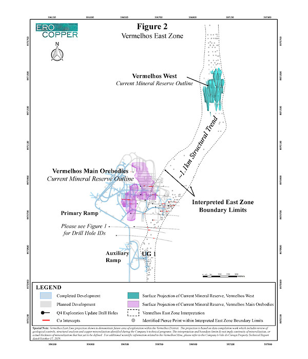
These high-grade results are part of a group of 7 holes drilled within 100 meters of surface, that when combined with analysis following the discovery of the Vermelhos East Zone, including the results of the 11 holes outlined in this press release, confirm the Vermelhos East Zone is not a discrete zone, but rather a semi-continuous mineralized structure extending from the Vermelhos Mine (UG1 mining area) in a north-northeast direction to the Vermelhos West deposit – a combined strike length of approximately 1.1 kilometers. To date, the Vermelhos East Zone has been delineated from surface to a depth of approximately 400 meters and remains open along strike and to depth. Further drill testing to determine continuity of the high-grade portions of the Vermelhos East Zone is a top priority of the Company’s ongoing exploration efforts in the Vermelhos District.
- Within the Vermelhos Mine’s main orebodies, drill results continue to expand known areas of high-grade mineralization in and around the mine’s recently completed infrastructure. Results during the period are highlighted by holes:
- FVS-257 that intersected 38.2 meters grading 7.29% copper including 23.1 meters grading 11.16% copper and 10.1 meters grading 4.59% copper;
- FVS-328 that intersected 38.2 meters grading 6.79% copper including 19.4 meters grading 8.38% copper; and,
- FVS-331 that intersected 31.5 meters grading 8.72% copper and 8.5 meters grading 5.48% copper.
These results reflect significant increases in previously modeled thicknesses of the main Vermelhos orebodies in the immediate areas surrounding these new intercepts. In addition, the results are the product of the Company’s systematic, ongoing, borehole electromagnetic (“EM”) program that is identifying EM targets within and adjacent to the main Vermelhos deposit with positive results. The Company intends to expand the use of the borehole EM to its other operations and regional exploration program to compliment the results from its recently completed airborne geophysical survey.
This update encompasses exploration drill results received for the Company’s exploration programs from August through to the end of November 2018. Expansions and extensions as referenced herein reflect mineralization not captured in the Company’s mineral resource and mineral reserve models used in the recently announced National Instrument 43-101, Standards of Disclosure for Mineral Projects (“NI 43-101”) compliant mineral resource and reserve update (as further detailed in the Company’s press release dated September 5, 2018). Currently, 19 drill rigs are operating on the property.
VERMELHOS DISTRICT
The Vermelhos District is located approximately 80 kilometers to the north of the Pilar Mine and Caraíba Mill complex and includes the newly constructed high-grade Vermelhos Mine. Drilling is focused on expansion and new discovery initiatives (including the Vermelhos East Zone) within and immediately adjacent to the Vermelhos Mine. Five drill rigs are currently operating within the District.
Vermelhos East Zone Extension
The Vermelhos East Zone discovery (see press release dated September 25, 2018 for announcement of the Vermelhos East Zone discovery) is located approximately 100 meters to the east of mineralization comprising the main Vermelhos orebodies and lies on the eastern side of an intrusive body. The zone of mineralization, to date, has been delineated from surface copper oxide mineralization to an interpreted depth of approximately 400 meters below surface. Recent drill results, combined with data compilation work performed subsequent to the initial discovery, supports a new interpretation of the Vermelhos East Zone as a semi-continuous mineralized trend extending from the UG1 mining area of the Vermelhos Mine to the Vermelhos West deposit – a combined strike length of approximately 1.1 kilometers. The interpretation is based on the compilation of 250 drill hole intercepts (including oxide drilling performed by the Company and historical drilling incorporated into the current mineral resource estimate of the Vermelhos West deposit). Additional test work is underway to further delineate the continuity of recently identified high-grade mineralization within the overall mineralized trend.
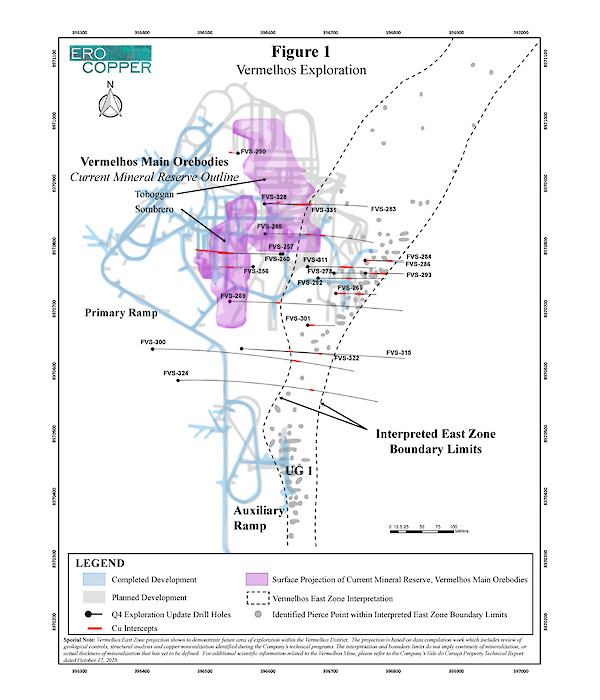
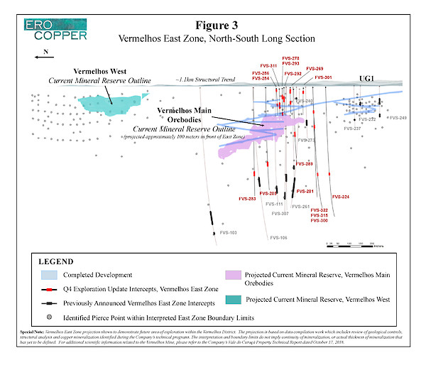
During the period, results from 11 drill holes were received that highlight extensions of the Vermelhos East Zone, as shown in the following table. Please see Figures 1 and 2 for collar locations and Figure 3 for a north-south long section highlighting the 1.1 kilometer mineralized trend of the Vermelhos East Zone.
Hole ID | From (m) | To (m) | Length (m) | Cu (%) |
|---|---|---|---|---|
FVS-269* | 3.1 | 29.4 | 26.3 | 3.63 |
including | 12.7 | 28.3 | 15.7 | 4.93 |
FVS-278 | 121.4 | 127.4 | 6.0 | 1.15 |
FVS-284 | 50.1 | 58.9 | 8.8 | 1.18 |
FVS-285 | 327.6 | 331.2 | 3.6 | 1.43 |
and | 336.8 | 339.8 | 3.0 | 1.45 |
FVS-286* | 6.2 | 12.2 | 6.0 | 1.06 |
FVS-292 | 64.2 | 80.7 | 16.5 | 4.22 |
including | 70.2 | 79.2 | 9.0 | 6.10 |
FVS-293 | 38.8 | 44.8 | 6.0 | 2.07 |
including | 38.8 | 41.8 | 3.0 | 3.01 |
FVS-300 | 408.1 | 426.4 | 18.3 | 1.49 |
including | 411.1 | 416.1 | 5.0 | 3.03 |
FVS-301 | 16.7 | 25.3 | 8.6 | 2.37 |
including | 20.7 | 24.3 | 3.6 | 3.97 |
FVS-311 | 81.2 | 108.5 | 27.4 | 8.39 |
including | 84.2 | 101.9 | 17.7 | 10.76 |
FVS-324 | 400.6 | 404.0 | 3.3 | 1.11 |
Drill holes were drilled from surface. Holes not included are either pending assay results, have been included in a different section of this press release for clarity of discussing drill results or were previously included in a prior press release. The length of intercept may not represent the true width of mineralization. Values may not add up due to rounding. From, to and mineralized intercepts are rounded to the nearest tenth of a meter. (*) indicates drill holes with near-surface copper intercepts containing oxide mineralization.
Vermelhos Main Orebody Expansions
Exploration drilling within the main Vermelhos orebodies continues to target expansions and extensions of the mineral resource, with a focus during the period on drilling several EM anomalies identified during the Company’s systematic and ongoing bore hole EM program. Drilling during the period continued to expand and extend the mineral resource and mineral reserve models of the Vermelhos Mine as defined in the current NI 43-101 Technical Report.
Expansions within the Sombrero orebody of the Vermelhos Mine are highlighted by hole FVS-256 that intersected 35.1 meters grading 2.70% copper including 12.3 meters grading 6.30% copper and 8.2 meters grading 1.96% copper, hole FVS-257 that intersected 38.2 meters grading 7.29% copper including 23.1 meters grading 11.16% copper and 10.1 meters grading 4.59% copper including 2.0 meters grading 18.07% copper. The mineralized thicknesses of these intercepts are significant as they represent an approximate 40% increase in the modeled thicknesses of the orebody in the immediate areas surrounding these holes within the current mineral resource and reserve estimate.
Additionally, expansions of the Toboggan orebody of the Vermelhos Mine are highlighted by hole FVS-328 that intersected 38.2 meters grading 6.79% copper including 19.4 meters grading 8.38% copper and hole FVS-331 that intersected 31.5 meters grading 8.72% copper and 8.5 meters grading 5.48% copper. The mineralized thicknesses of these intercepts are significant as they represent an approximate 80% increase in the modeled thicknesses of the orebody in the immediate areas surrounding these holes contained within the current mineral resource and reserve estimate.
During the period, results from 11 drill holes were received that highlight expansions of the main Vermelhos orebodies, as shown in the following table. Please see Figure 1 for drill collar locations.
Hole ID | From (m) | To (m) | Length (m) | Cu (%) |
|---|---|---|---|---|
FVS-256 | 115.4 | 150.5 | 35.1 | 2.70 |
including | 130.4 | 142.7 | 12.3 | 6.30 |
and | 156.5 | 164.6 | 8.2 | 1.96 |
FVS-257 | 147.6 | 185.8 | 38.2 | 7.29 |
including | 149.6 | 172.8 | 23.1 | 11.16 |
and | 193.2 | 203.3 | 10.1 | 4.59 |
including | 198.6 | 200.6 | 2.0 | 18.07 |
FVS-260 | 177.7 | 189.3 | 11.6 | 1.12 |
FVS-283 | 176.9 | 209.9 | 32.9 | 2.77 |
including | 185.3 | 187.4 | 2.1 | 12.43 |
FVS-285 | 172.6 | 186.8 | 14.1 | 1.32 |
and | 220.1 | 231.2 | 11.2 | 2.40 |
FVS-289 | 112.0 | 116.3 | 4.4 | 1.00 |
FVS-290 | 216.7 | 239.2 | 22.6 | 0.89 |
including | 237.2 | 239.2 | 2.0 | 3.53 |
FVS-315 | NSI | NSI | NSI | NSI |
FVS-322 | 93.5 | 95.9 | 2.5 | 2.34 |
and | 118.4 | 123.7 | 5.3 | 1.94 |
and | 191.2 | 195.2 | 4.0 | 0.88 |
FVS-328 | 184.8 | 222.9 | 38.2 | 6.79 |
including | 185.8 | 205.1 | 19.4 | 8.38 |
FVS-331 | 179.1 | 210.6 | 31.5 | 8.72 |
and | 215.6 | 224.1 | 8.5 | 5.48 |
NSI indicates no significant intercept, based on cut-off grade of 0.68% copper. Drill holes were drilled from surface. Holes not included are either pending assay results, have been included in a different section of this press release for clarity of discussing drill results or were previously included in a prior press release. The length of intercept may not represent the true width of mineralization. Values may not add up due to rounding. From, to and mineralized intercepts are rounded to the nearest tenth of a meter.
The main orebodies remain open to the north, south and to depth and one of the five drill rigs operating at Vermelhos will continue to evaluate their extensions. The remaining four drill rigs will continue to test the continuity of the Vermelhos East Zone over its 1.1 kilometer strike length.
Vermelhos Mine - Nickel and Palladium
Test work is underway to quantify the significance of recent occurrences of high-grade nickel and palladium within the main Vermelhos orebodies at depth and their relationship to the known copper mineral resources. While, to date, average nickel grades in the orebodies, based on approximately 1,300 drill core samples, are approximately 0.25% nickel, with a maximum assay result of 5.09% nickel, recent grab samples taken from a development heading containing massive pentlandite measuring approximately 1 meter by 1 meter at level +285 of the Sombrero orebody returned assay values up to 21.7% nickel. While these grab samples are not representative and should not be relied upon, the discovery of high grade, massive pentlandite within the deposit is an unexpected positive development.
Additionally, over 500 samples of core have been recently analyzed for platinum group metal (“PGM”) content. The results were anomalous for palladium with an average assay result of 0.19 grams per tonne palladium, and a maximum of 1.19 grams per tonne palladium. There is a strong observed relationship between high-grade copper mineralization and palladium content based on the samples analyzed to date.
In the New Year, a portion of the ongoing drill program at Vermelhos will focus on drilling deeper holes below the Vermelhos main orebodies to test targets at depth and allow the Company to conduct deeper downhole EM surveys to further evaluate the potential for additional copper, nickel and PGM mineralization at Vermelhos.
PILAR DISTRICT
The Pilar District encompasses the area surrounding the Pilar underground mine, Caraíba Mill complex and the past producing open pit Pilar and R22 Mines. Ten drill rigs are currently operating within the District.
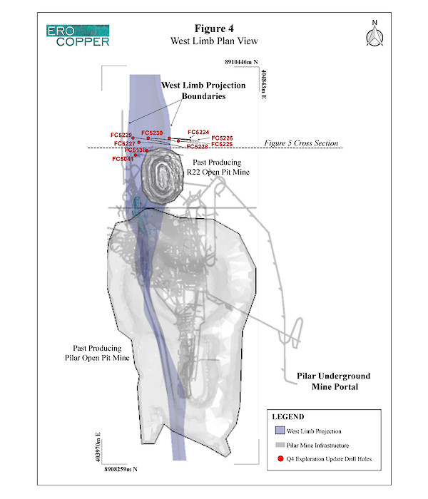
During the period, expansion and extensional drilling continued to focus on the West Limb and Deepening Extension zone. Three underground and one surface drill rig are currently evaluating the extent of the West Limb while four underground core rigs are operating in the Deepening Extension zone (see the Company’s press release dated May 17, 2018 for the announcement of the West Limb discovery). One additional surface rig and one additional underground drill rig are currently targeting other areas of the mine.
West Limb
Exploration drilling at the West Limb is focused on infill, extension and twin-hole drilling of the previously announced West Limb discovery. Drilling has predominately focused on the area beneath the past producing R22 open pit mine and extensions along strike to the north, highlighted by hole FC5229 that intersected 61.5 meters grading 1.91% copper, 6.7 meters grading 0.95% copper, 8.6 meters grading 1.20% copper and 4.0 meters grading 1.37% copper. Underground drill rigs have recently commenced drill programs to test the southern extent of mineralization within the West Limb.
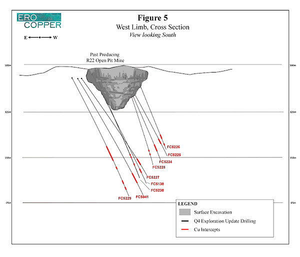
During the period, results from 9 drill holes were received that highlight extensional drilling of the West Limb, as shown in the following table. Please see Figure 4 for collar locations and Figure 5 for a cross section of the West Limb drill results.
Hole ID | From (m) | To (m) | Length (m) | Cu (%) |
|---|---|---|---|---|
FC5041 | 419.2 | 467.2 | 48.0 | 1.31 |
FC5224 | 282.8 | 302.7 | 19.9 | 2.66 |
including | 290.3 | 296.5 | 6.1 | 4.93 |
FC5225 | 303.9 | 308.1 | 4.2 | 0.74 |
FC5226 | 264.2 | 271.0 | 6.8 | 4.71 |
and | 275.0 | 285.0 | 10.0 | 1.27 |
FC5227 | 373.4 | 401.2 | 27.8 | 1.61 |
including | 394.2 | 400.2 | 6.0 | 2.66 |
FC5228 | 239.1 | 249.9 | 10.9 | 1.62 |
including | 243.0 | 249.9 | 6.9 | 1.83 |
and | 257.9 | 259.9 | 2.0 | 2.41 |
and | 270.9 | 279.3 | 8.4 | 1.60 |
FC5229 | 286.3 | 347.8 | 61.5 | 1.91 |
and | 375.5 | 382.3 | 6.7 | 0.95 |
and | 437.6 | 446.3 | 8.6 | 1.20 |
and | 465.4 | 469.4 | 4.0 | 1.37 |
FC5230 | 325.8 | 331.8 | 6.0 | 0.91 |
and | 336.8 | 342.8 | 6.0 | 0.93 |
and | 364.5 | 372.7 | 8.2 | 1.63 |
FC5138 | 369.2 | 372.2 | 3.0 | 1.25 |
and | 386.3 | 406.0 | 19.8 | 1.22 |
including | 400.2 | 405.2 | 5.0 | 1.77 |
Drill holes were drilled from surface. Holes not included are either pending assay results, have been included in a different section of this press release for clarity of discussing drill results or were previously included in a prior press release. The length of intercept may not represent the true width of mineralization. Values may not add up due to rounding. From, to and mineralized intercepts are rounded to the nearest tenth of a meter.
The Deepening Extension
The Deepening Extension drilling is currently targeting mineralization on the East Limb of the Pilar Mine between level -725 and level -1040 approximately 1,200 meters to 1,500 meters below surface and approximately 100 meters laterally from the current level of the primary ramp (completed to level -881). During the period, results for 18 holes were received that continue to demonstrate extensions of the modeled mineralization within the zone. The results are highlighted by extensions beyond what was previously believed to be the southern limit of the Deepening Extension zone in hole FC38151 that intersected 5.6 meters grading 5.36% copper as well as hole FC38153 that intersected 8.3 meters grading 2.59% copper and 17.0 meters grading 2.05% copper. These results indicate that the Deepening Extension remains open to the south.
In addition, hole FC44204, that intersected 6.0 meters grading 7.91% copper including 3.0 meters grading 11.03% copper, was drilled approximately 330 meters north of the aforementioned holes and approximately 225 meters south of the previously announced “Deep Discovery” holes (see press release dated June 6, 2018). This hole encountered higher grade mineralization similar to copper grades encountered previously within the Deepening Extension to the north (reference previously announced hole FC4884 that intersected 18.0 meters grading 6.28% copper and previously announced hole FC4986 that intersected 6.9 meters grading 5.82% copper and 15.4 meters grading 3.71% copper). High-grade copper intercepts have now occurred over a combined north-south strike length of approximately 550 meters within the Deepening Extension zone. Additional follow-up drilling to determine continuity of high-grade mineralization in this area is currently underway.
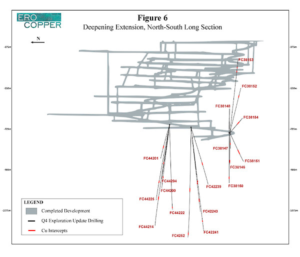
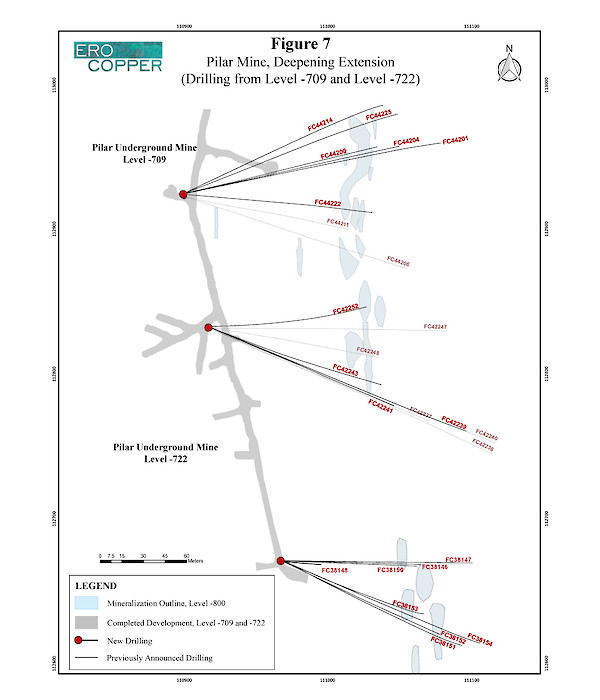
During the period, results from 18 drill holes were received that highlight extensions of the Deepening Extension zone, as shown in the following table. Please see Figures 6 for a north-south long section of the Deepening Extension zone and Figure 7 for collar locations.
Hole ID | From (m) | To (m) | Length (m) | Cu (%) |
|---|---|---|---|---|
FC38146 | 150.6 | 158.6 | 8.0 | 1.07 |
FC38147 | NSI | NSI | NSI | NSI |
FC38148 | NSI | NSI | NSI | NSI |
FC38150 | 210.0 | 216.4 | 6.4 | 1.14 |
FC38151 | 136.1 | 141.7 | 5.6 | 5.36 |
FC38152 | 183.3 | 186.8 | 3.5 | 0.99 |
FC38153 | 274.6 | 282.9 | 8.3 | 2.59 |
and | 294.1 | 311.2 | 17.0 | 2.05 |
FC38154 | 110.0 | 115.7 | 5.7 | 1.02 |
FC42239 | NSI | NSI | NSI | NSI |
FC42241 | NSI | NSI | NSI | NSI |
FC42243 | 339.2 | 343.2 | 4.0 | 0.97 |
FC42252 | 274.4 | 283.6 | 9.2 | 1.37 |
FC44200 | 255.0 | 260.1 | 5.0 | 1.97 |
including | 256.9 | 260.8 | 3.9 | 2.41 |
FC44201 | 154.9 | 169.4 | 14.5 | 2.04 |
FC44204 | 200.4 | 206.4 | 6.0 | 7.91 |
including | 202.4 | 205.4 | 3.0 | 11.03 |
FC44214 | 334.2 | 343.2 | 9.0 | 2.39 |
including | 334.2 | 338.2 | 4.0 | 4.07 |
FC44222 | 379.3 | 383.3 | 4.0 | 1.79 |
FC44225 | 272.8 | 280.4 | 7.6 | 1.72 |
NSI indicates no significant intercept based on cut-off grade of 0.68% copper. The drill holes were drilled from the -709 and -722 levels. Holes not included are either pending assay results, have been included in a different section of this press release for clarity of discussing drill results or were previously included in a prior press release. The length of intercept may not represent the true width of mineralization. Values may not add up due to rounding. From, to and mineralized intercepts are rounded to the nearest tenth of a meter.
SURUBIM DISTRICT
The Surubim District is located approximately 40 kilometers to the north of the Caraíba Mill complex and comprises the Surubim open pit mine and past producing Angicos open pit mine. Two surface drill rigs are operating within the Surubim District.
One surface drill rig at Surubim continues to test continuity of mineralization to depth below the open pit mine, and one drill rig is currently evaluating a new exploration target adjacent to the Surubim Mine.
REGIONAL EXPLORATION
The Company in nearing completion of the data interpretation and targeting phase of the regional airborne geophysical survey comprised of both electromagnetic and gravity systems. To date, a significant number of high priority target areas have been identified and detailed analysis of each target area has commenced. Drill testing of the first two targets, located near the Pilar Mine, is currently underway, with two exploration drill rigs operating on these targets.
ABOUT ERO COPPER CORP
Ero Copper Corp, headquartered in Vancouver, B.C., is focused on copper production growth from the Vale do Curaçá Property, located in Bahia, Brazil. The Company’s primary asset is a 99.6% interest in the Brazilian copper mining company, MCSA, 100% owner of the Vale do Curaçá Property with over 39 years of operating history in the region. The Company currently mines copper ore from the Pilar underground mine, the Surubim open pit mine and its newly constructed Vermelhos underground mine. In addition to the Vale do Curaçá Property, MCSA owns 100% of the Boa Esperanҫa development project, an IOCG-type copper project located in Pará, Brazil. Additional information on the Company and its operations, including Technical Reports on both the Vale do Curaçá and Boa Esperanҫa properties, can be found on the Company’s website (www.erocopper.com) and on SEDAR (www.sedar.com).
QUALITY ASSURANCE / QUALITY CONTROL
The Company is currently drilling on surface and underground with core drill rigs using a combination of owned and third-party contracted drill rigs. During the period from August 2018 to November 2018 third party drill rigs were operated by Major Drilling, Layne Christensen Co., and DrillGeo Geologia e Sondagem Ltda., all of whom are independent of the Company. Drill core is logged, photographed and split in half using a diamond core saw at MCSA’s secure core logging and storage facilities. Half of the drill core is retained on site and the other half core is used for analysis, with samples collected on one-meter sample intervals unless an interval crosses a geological contact. Reverse circulation cuttings are split at the drill rig using one-meter sample intervals. All sample preparation is performed in MCSA’s secure on-site laboratory. Total copper is determined using a nitric-hydrochloric acid digestion and Atomic Absorption Spectrometry (“AAS”) and/or Titration. Oxide copper values are determined using sulfuric acid digestion followed by AAS. All recent sample results have been monitored through a QA/QC program that includes the insertion of certified standards, blanks, and pulp and reject duplicate samples. Regular check-assays are submitted to ALS Brasil LTDA’s facility located in Vespasiano, Minas Gerais, Brazil, at a rate of approximately 5%. ALS Brasil LTDA is independent of the Company.
Rubens Mendonça, MAusIMM, Chartered Professional – Mining, has reviewed and approved the scientific and technical information contained in this press release. Mr. Mendonça is a Qualified Person and is independent of Ero Copper Corp. as defined by NI 43-101.
ERO COPPER CORP. | For further information contact: |
Signed:“David Strang” | Makko DeFilippo, Vice President, Corporate Development |
David Strang, President & CEO | (604) 429-9244 |
CAUTION REGARDING FORWARD LOOKING INFORMATION AND STATEMENTS This Press Release contains “forward-looking information” within the meaning of applicable Canadian securities laws. Forward-looking information includes statements that use forward-looking terminology such as “may”, “could”, “would”, “will”, “should”, “intend”, “target”, “plan”, “expect”, “budget”, “estimate”, “forecast”, “schedule”, “anticipate”, “believe”, “continue”, “potential”, “view” or the negative or grammatical variation thereof or other variations thereof or comparable terminology. Such forward-looking information includes, without limitation, statements with respect to the estimation of mineral reserves and mineral resources, the significance of any particular exploration program or result, the significance of any nickel and PGM occurrences within the Company’s operations, and the Company’s expectations for current and future exploration plans including further extensions and expansion of mineralization near the Company’s existing operations and throughout the Curaçá Valley.
Forward-looking information is not a guarantee of future performance and is based upon a number of estimates and assumptions of management in light of management’s experience and perception of trends, current conditions and expected developments, as well as other factors that management believes to be relevant and reasonable in the circumstances, as of the date of this Press Release including, without limitation, assumptions about: favourable equity and debt capital markets; the ability to raise any necessary additional capital on reasonable terms to advance the production, development and exploration of the Company’s properties and assets; future prices of copper and other metal prices; the timing and results of exploration and drilling programs; the accuracy of any mineral reserve and mineral resource estimates; the geology of the Vale do Curaçá Property and the Boa Esperanҫa Property being as described in the technical reports for these properties; production costs; the accuracy of budgeted exploration and development costs and expenditures; the price of other commodities such as fuel; future currency exchange rates and interest rates; operating conditions being favourable such that the Company is able to operate in a safe, efficient and effective manner; political and regulatory stability; the receipt of governmental, regulatory and third party approvals, licenses and permits on favourable terms; obtaining required renewals for existing approvals, licenses and permits on favourable terms; requirements under applicable laws; sustained labour stability; stability in financial and capital goods markets; availability of equipment; positive relations with local groups and the Company’s ability to meet its obligations under its agreements with such groups; and satisfying the terms and conditions of the Company’s current loan arrangements. While the Company considers these assumptions to be reasonable, the assumptions are inherently subject to significant business, social, economic, political, regulatory, competitive and other risks and uncertainties, contingencies and other factors that could cause actual actions, events, conditions, results, performance or achievements to be materially different from those projected in the forward-looking information. Many assumptions are based on factors and events that are not within the control of the Company and there is no assurance they will prove to be correct.
Furthermore, such forward-looking information involves a variety of known and unknown risks, uncertainties and other factors which may cause the actual plans, intentions, activities, results, performance or achievements of the Company to be materially different from any future plans, intentions, activities, results, performance or achievements expressed or implied by such forward-looking information. Such risks include, without limitation the risk factors listed under the heading “Risk Factors” in the Annual Information Form of the Company for the year ended December 31, 2017, dated March 28, 2018.
Although the Company has attempted to identify important factors that could cause actual actions, events, conditions, results, performance or achievements to differ materially from those described in forward-looking information, there may be other factors that cause actions, events, conditions, results, performance or achievements to differ from those anticipated, estimated or intended.
The Company cautions that the foregoing lists of important assumptions and factors are not exhaustive. Other events or circumstances could cause actual results to differ materially from those estimated or projected and expressed in, or implied by, the forward-looking information contained herein. There can be no assurance that forward-looking information will prove to be accurate, as actual results and future events could differ materially from those anticipated in such information. Accordingly, readers should not place undue reliance on forward-looking information.
Forward-looking information contained herein is made as of the date of this press release and the Company disclaims any obligation to update or revise any forward-looking information, whether as a result of new information, future events or results or otherwise, except as and to the extent required by applicable securities laws.
GENERAL Information of a scientific or technical nature in respect of the Vale do Curaçá Property included in this press release is based upon the Vale do Curaçá technical report entitled “2018 Updated Mineral Resources and Mineral Reserves Statements of Mineração Caraíba’s Vale do Curaçá Mineral Assets, Curaçá Valley”, dated October 17, 2018 with an effective date of August 1, 2018, prepared by Rubens Jose De Mendonça, MAusIMM, of Planminas and Porfirio Cabaleiro Rodrigues, MAIG, Fábio Valério Cãmara Xavier, MAIG, and Bernardo Horta de Cerqueira Viana, MAIG, all of GE21 Consultoria Mineral, whom are independent qualified persons under NI 43-101.
Please see the Vale do Curaçá Technical Report filed on the Company’s profile at www.sedar.com, for details regarding the data verification undertaken with respect to the scientific and technical information included in this press release regarding the Vale do Curaçá Property for additional details regarding the related exploration information, including interpretations, the QA/QC employed, sample, analytical and testing results and for additional details regarding the Mineral Resource and Mineral Reserve estimates discussed herein.
Cautionary Notes Regarding Mineral Resource and Reserve Estimates In accordance with applicable Canadian securities regulatory requirements, all mineral reserve and mineral resource estimates of the Company disclosed or incorporated by reference in this press release have been prepared in accordance with NI 43-101 and are classified in accordance with the CIM Standards.
Mineral resources which are not mineral reserves do not have demonstrated economic viability. Pursuant to the CIM Standards, mineral resources have a higher degree of uncertainty than mineral reserves as to their existence as well as their economic and legal feasibility. Inferred mineral resources, when compared with Measured or Indicated mineral resources, have the least certainty as to their existence, and it cannot be assumed that all or any part of an Inferred mineral resource will be upgraded to an Indicated or Measured mineral resource as a result of continued exploration. Pursuant to NI 43-101, Inferred mineral resources may not form the basis of any economic analysis. Accordingly, readers are cautioned not to assume that all or any part of a mineral resource exists, will ever be converted into a mineral reserve, or is or will ever be economically or legally mineable or recovered.