Vancouver, British Columbia – Ero Copper Corp. (the “Company”) (TSX: ERO) is pleased to provide a quarterly update on the ongoing exploration and resource definition drilling programs at its Pilar, Vermelhos and Surubim mineral districts, all part of its 99.6% owned Vale de Curaçá Property located in Bahia State, Brazil. Significant new drilling results are highlighted below:
- At the Vermelhos mine, hole FVS-212 intersected 39.8 meters grading 5.57% copper including 21.9 meters grading 9.43% copper. This hole is the first to test the south extensions of the main Vermelhos deposit and was drilled approximately 25 meters south of the main Vermelhos ore bodies. The newly identified extension remains open to the south.
- At the Pilar mine, holes FC4884 intersected 18.0 meters grading 6.28% copper and FC4986 intersected 6.9 meters grading 5.82% copper and 15.4 meters grading 3.71% copper. These two holes are the deepest intercepts yet of copper mineralization and were drilled approximately 235 meters below the extent of all previously known mineralization. They represent down-dip extensions of copper mineralization on the East Limb of the Pilar Mine with the zone remaining open along strike and at depth.
Other notable drilling highlights include:
- Hole FC5331 that intersected 44.7 meters grading 1.56% copper including 19.4 meters grading 2.24% copper (part of the Pilar North Extension - R22 Underground program);
- Hole CRN7-64 that intersected 11.0 meters grading 7.70% oxide copper (12.06% copper total) (part of the Vermelhos oxide program).
This update encompasses results received for the various exploration drill programs from February through to the end of April 2018. While drilling and assaying remains ongoing, data collection for the Company’s mid-year National Instrument 43-101 (“NI 43-101”) update, expected to be released during the third quarter of 2018, has been cut-off as at the end of May.
PILAR DISTRICT
The Pilar District encompasses the area surrounding the Pilar underground mine, Caraíba mill complex and the past producing open pit Pilar and R22 mines. Seven drill rigs are currently operating within the district.
During the period, down-dip continuity of the East Limb was tested below the previous extent of all known mineralization at the Pilar Mine. Through the end of the period, complete results had been received for two drill holes (FC4884 and FC4986 – results highlighted earlier in this news release and detailed in the table below). Mineralization has now been identified on the East Limb of the Pilar Mine to level -1200, approximately 1,650 meters below surface, and 235 meters below the previously known extent of mineralization. Copper mineralization at the Pilar Mine’s East Limb has now been mined, delineated or identified over a vertical extent of 1,650 meters. The newly identified zone on the East Limb remains open along strike and to depth.
Other drilling activities in the district during the period focused on infill and step-out drilling of the previously announced Deepening Extension (where 4 underground core rigs are operating) and North Extension zone (where one surface drill rig is operating). The remaining rigs are evaluating the extent of the newly discovered West Limb (see the Company’s press release dated May 17, 2018 for the announcement of the West Limb discovery).
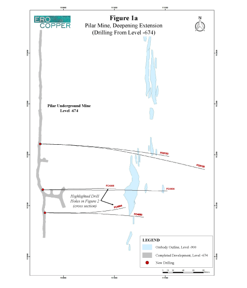
The Deepening Extension program has been targeting a zone of mineralization on the East Limb between level -750 and level -900 approximately 1,200 meters to 1,350 meters below surface and approximately 100 meters laterally from the current level of the primary ramp (completed to level -850). During the period from February through April 2018, assays were received for 22 holes comprising 6,887 meters drilled. To date, the program focused on upgrading known resources and newly identified mineralization between sections 40 and 49 (approximately 400 meters in combined strike length). The most continuous and highest-grade copper mineralization has been delineated over a north-south strike length of approximately 180 meters between sections 45 and 49. The results of the East Limb Deepening Extension programs, including the aforementioned discovery holes drilled to depth, are shown in the following table. Please see Figures 1a, 1b and 2 for collar locations and a cross section of the Pilar East Limb showing the new discovery at depth.
| Hole ID | From (m) | To (m) | Length (m) | Cu (%) |
|---|---|---|---|---|
| FC42218 | 46.6 | 54.3 | 7.7 | 0.73 |
| FC42220 | 40.9 | 46.4 | 5.5 | 0.85 |
| and | 134.1 | 151.2 | 17.1 | 0.66 |
| FC42221 | 72.4 | 75.9 | 3.5 | 1.03 |
| FC42222 | 219.2 | 240.6 | 21.4 | 1.82 |
| including | 225.0 | 234.5 | 9.5 | 2.24 |
| FC42223 | 280.7 | 311.7 | 31.0 | 1.04 |
| including | 280.7 | 277.4 | 5.0 | 3.50 |
| FC42224 | NSI | NSI | NSI | NSI |
| FC42225 | 202.5 | 212.6 | 10.1 | 2.06 |
| and | 280.7 | 295.3 | 14.6 | 1.12 |
| FC42226 | 138.2 | 144.7 | 6.5 | 1.33 |
| FC44182 | 166.3 | 175.8 | 9.5 | 3.52 |
| FC44183 | 202.3 | 207.0 | 4.7 | 0.64 |
| FC44184 | 250.7 | 255.5 | 4.8 | 2.02 |
| FC44185 | 146.2 | 166.2 | 20.0 | 2.00 |
| FC44186 | 232.6 | 243.8 | 11.2 | 0.84 |
| FC44187 | 149.0 | 172.7 | 23.7 | 1.52 |
| including | 155.7 | 166.5 | 10.8 | 2.02 |
| FC44189 | 188.0 | 196.2 | 8.2 | 0.83 |
| FC44196 | 129.2 | 154.9 | 25.7 | 2.85 |
| including | 129.2 | 145.5 | 16.4 | 3.48 |
| FC4883 | 291.4 | 304.9 | 13.6 | 1.89 |
| including | 291.4 | 295.4 | 4.0 | 3.72 |
| FC4884 | 385.4 | 403.4 | 18.0 | 6.28 |
| FC4984 | NSI | NSI | NSI | NSI |
| FC4986 | 514.2 | 521.8 | 6.9 | 5.82 |
| and | 531.1 | 546.5 | 15.4 | 3.71 |
| FC5133 | 242.8 | 246.0 | 3.2 | 2.77 |
| FC5135 | 278.0 | 284.4 | 6.4 | 2.85 |
The drill holes were drilled from the -674, -709 and -722 levels. The length of intercept may not represent the true width of mineralization. Values may not add up due to rounding. From, to and mineralized intercepts are rounded to the nearest tenth of a meter. NSI: no significant intercept.
All North Extension drilling during the period focused on the previously announced mineralization beneath the past producing R22 open pit mine (“R22 Underground”) located approximately 100 meters west of the current mineral reserves and scheduled mining area of P1P2NE, and approximately 250 meters from the main ramp. Please refer to the Company’s press release dated February 22, 2018 for the announcement of this discovery.
The zone occurs at approximately 300 meters depth below surface, strikes approximately 225 meters in a north-south direction and remains open both up-dip and to depth. As was detailed in the announcement, the discovery’s proximity to the P1P2NE mineral reserves, already included in the Company’s mine plan, is potentially significant as material from the new discovery may increase the total amount of production forecast to be mined from the shallow underground portion of the Pilar Mine. Work remains ongoing to test potential continuity of P1P2W, P1P2NE, the North Extension, the East Limb and the recently announced West Limb discovery.
During the period from February through April 2018, assays were received for 12 holes comprising 4,883 meters drilled. These holes were drilled from surface into the R22 Underground target and serve to further delineate the continuity of copper mineralization within the North Extension zone. The results are shown in the following table (see Figure 3 for drill collar locations):
| Hole ID | From (m) | To (m) | Length (m) | Cu (%) |
|---|---|---|---|---|
| FC4981 | NSI | NSI | NSI | NSI |
| FC4982 | 429.2 | 447.5 | 18.3 | 1.41 |
| FC4983 | 313.0 | 330.4 | 17.3 | 1.36 |
| including | 320.4 | 330.4 | 10.0 | 1.94 |
| FC5026 | 383.2 | 421.7 | 38.5 | 0.69 |
| including | 383.2 | 389.9 | 6.7 | 1.95 |
| FC5031 | 377.5 | 383.5 | 6.0 | 1.13 |
| and | 410.5 | 426.6 | 16.1 | 1.15 |
| including | 416.5 | 426.6 | 10.1 | 1.66 |
| FC5132 | 334.5 | 358.9 | 24.4 | 0.84 |
| including | 348.8 | 358.9 | 10.7 | 1.01 |
| FC5134 | 347.3 | 362.5 | 15.2 | 1.81 |
| FC5331 | 283.7 | 328.4 | 44.7 | 1.56 |
| including | 300.8 | 320.2 | 19.4 | 2.24 |
| FC5332 | 290.4 | 293.8 | 3.4 | 1.08 |
| FC5333 | NSI | NSI | NSI | NSI |
| FC5407 | NSI | NSI | NSI | NSI |
| FC5408 | 240.4 | 244.6 | 4.2 | 1.10 |
The drill holes were drilled from surface. The length of intercept may not represent the true width of mineralization. Values may not add up due to rounding. From, to and mineralized intercepts are rounded to the nearest tenth of a meter. NSI: no significant intercept.
Exploration drilling at the Pilar Mine is being transitioned to focus on infill, extension and twin-hole drilling of the recently announced West Limb discovery, including to depth and the newly discovered extensions to depth of the Deepening Extension zone.
VERMELHOS DISTRICT
The Vermelhos District is located approximately 80 kilometers to the north of the Caraíba mill complex and includes the high-grade Vermelhos copper mine currently under construction. Four surface core drill rigs, as well as one reverse circulation “RC” rig, are currently operating in the district.
From February through April 2018, 11 step-out holes were drilled to test both northern and southern extensions to the main Vermelhos ore bodies. To the south, two drill holes were drilled 25 and 50 meters from the ore bodies during the period. Complete assay results were received for the first hole, FVS212, drilled approximately 25 meters to the south, that intersected 39.8 meters grading 5.57% copper including 21.9 meters grading 9.43% copper. Assay results for the second hole are pending. Mineralization remains open to the south. To the north, 6 holes were drilled 10, 25 and 75 meters north-northwest of the main ore bodies. As at the end of the period, complete assay data was pending for these holes.
The majority of drilling at Vermelhos during the period remained focused on upgrading mineral resources and definition drilling for mine planning. From February through April 2018, assays were received for 27 drill holes comprising 6,952 meters of drilling in and around the main Vermelhos deposit. The results of these assays are shown in the table below (see Figure 4 for drill collar locations):
| Hole ID | From (m) | To (m) | Length (m) | Cu (%) |
|---|---|---|---|---|
| FVS-183 | 152.8 | 163.5 | 10.7 | 1.03 |
| FVS-184 | 63.6 | 68.6 | 5.0 | 1.51 |
| FVS-185 | NSI | NSI | NSI | NSI |
| FVS-186 | NSI | NSI | NSI | NSI |
| FVS-192 | 161.5 | 171.0 | 9.5 | 6.50 |
| FVS-194 | 182.1 | 186.1 | 4.0 | 1.07 |
| and | 222.1 | 227.7 | 5.6 | 1.29 |
| FVS-196 | 139.2 | 146.6 | 7.5 | 0.61 |
| FVS-201 | 215.0 | 234.3 | 19.3 | 7.45 |
| FVS-202 | NSI | NSI | NSI | NSI |
| FVS-203 | 231.1 | 247.0 | 15.9 | 9.89 |
| FVS-204 | 177.7 | 206.2 | 28.5 | 8.36 |
| FVS-205 | 182.6 | 193.8 | 11.2 | 5.33 |
| and | 205.9 | 226.4 | 20.5 | 10.14 |
| and | 237.4 | 246.9 | 9.5 | 4.06 |
| FVS-206 | NSI | NSI | NSI | NSI |
| FVS-207 | 148.9 | 153.2 | 4.3 | 2.23 |
| and | 157.7 | 164.6 | 6.9 | 3.09 |
| and | 183.0 | 186.4 | 3.3 | 2.57 |
| FVS-208 | NSI | NSI | NSI | NSI |
| FVS-209 | 129.6 | 139.6 | 10.0 | 1.19 |
| FVS-210 | NSI | NSI | NSI | NSI |
| FVS-211 | 215.8 | 243.8 | 28.0 | 7.21 |
| FVS-212 | 134.8 | 174.5 | 39.8 | 5.57 |
| including | 135.8 | 156.7 | 21.9 | 9.43 |
| FVS-213 | NSI | NSI | NSI | NSI |
| FVS-217 | 54.5 | 79.5 | 25.0 | 0.86 |
| and | 69.5 | 79.5 | 10.0 | 1.09 |
| FVS-218 | NSI | NSI | NSI | NSI |
| FVS-220 | 80.5 | 94.9 | 14.4 | 1.67 |
| FVS-222 | 68.1 | 71.9 | 3.8 | 1.38 |
| FVS-225 | 65.3 | 74.3 | 9.0 | 1.29 |
| FVS-226 | 84.0 | 104.0 | 20.0 | 2.06 |
| including | 88.7 | 98.7 | 10.0 | 3.11 |
| FVS-227 | NSI | NSI | NSI | NSI |
The drill holes were drilled from surface. The length of intercept may not represent the true width of mineralization. Values may not add up due to rounding. From, to and mineralized intercepts are rounded to the nearest tenth of a meter. NSI: no significant intercept. Listed holes include infill program with available assay results. Holes not included are either pending assay results or are not part of the Vermelhos infill program.
In addition, at the Vermelhos Mine, in-ore stope development within the UG1 mining area has resulted in the Company building a coarse ore stockpile on surface. To date, approximately 9,802 tonnes of material grading 4.37% copper has been mined and stockpiled on surface as a result of gallery development within the UG1 mining area.
The 15,000 meter copper oxide program at Vermelhos is designed to drill a 25 meter by 25 meter grid pattern from surface to a depth of approximately 40 meters along an open northeast trending zone, approximately 100 meters to 200 meters wide, of anomalous copper in soil samples located to the immediate north-northeast of the mine portal. During the period from February through April 2018, 138 holes have been drilled totaling 4,446 meters of drilling. To date, drilling has identified two distinct zones of oxide mineralization. Additional drilling will focus on the north-eastern most zone which remains open. During the period, complete results from 13 additional holes (in addition to the 17 holes previously announced) returned assay results grading above 0.20% copper oxide. The results from the 13 holes are shown in the table below (see Figure 5 for drill collar locations):
| Hole ID | From (m) | To (m) | Length (m) | Cu Oxide (%) | Cu Total (%) |
|---|---|---|---|---|---|
| CRN7-56 | 1.0 | 8.0 | 7.0 | 0.83 | 0.86 |
| CRN7-57 | 9.0 | 12.0 | 3.0 | 3.50 | 4.19 |
| CRN7-64 | 0.0 | 10.0 | 11.0 | 7.70 | 12.06 |
| CRN7-65 | 5.0 | 11.0 | 6.0 | 1.50 | 1.62 |
| CRN7-73 | 12.0 | 16.0 | 4.0 | 0.55 | 0.66 |
| CRN7-79 | 19.0 | 23.0 | 4.0 | 1.78 | 2.77 |
| CRN7-87 | 6.0 | 27.0 | 21.0 | 2.17 | 2.78 |
| CRN7-90 | 17.0 | 20.0 | 3.0 | 0.63 | 0.63 |
| CRN7-96 | 7.0 | 28.0 | 21.0 | 0.48 | 0.52 |
| including | 24.0 | 28.0 | 4.0 | 1.45 | 1.58 |
| CRN8-06 | 18.0 | 26.0 | 8.0 | 0.63 | 0.94 |
| CRN8-08 | 24.0 | 30.0 | 6.0 | 1.00 | 1.29 |
| CRN8-11 | 22.0 | 25.0 | 3.0 | 0.74 | 0.84 |
| CRN8-13 | 18.0 | 23.0 | 5.0 | 0.59 | 0.59 |
The drill holes were drilled from surface. The length of intercept may not represent the true width of mineralization. Values may not add up due to rounding. From, to and mineralized intercepts are rounded to the nearest tenth of a meter. Listed holes include Vermelhos oxide program with assay results above 0.20% copper oxide.
SURUBIM DISTRICT
The Surubim District is located approximately 40 kilometers to the north of the Caraíba mill complex and comprises the Surubim open pit mine and past producing Angicos open pit mine. Five surface drill rigs are operating within the Surubim District.
One drill rig is currently focused on extension drilling at the Surubim mine as part of a mine planning program to evaluate extensions to zones of mineralization currently being mined. The remaining drill rigs are currently evaluating new exploration targets adjacent to the Surubim Mine.
REGIONAL EXPLORATION
The Company has commenced its airborne electromagnetic and gravity geophysical survey of the Curaçá Valley targeting high-grade mineralization. To date, approximately 7% of the survey has been flown. Data processing and target identification commenced with the start of the program.
ABOUT ERO COPPER CORP
Ero Copper Corp, headquartered in Vancouver, B.C., is focused on copper production growth from the Vale do Curaçá Property, located in Bahia, Brazil. The Company’s primary asset is a 99.6% interest in the Brazilian copper mining company, Mineração Caraíba S.A. (“MCSA”), 100% owner of the Vale do Curaçá Property with over 37 years of operating history in the region. The Company currently mines copper ore from the Pilar underground and the Surubim open pit mines. In addition to the Vale do Curaçá Property, MCSA owns 100% of the Boa Esperanҫa development project, an IOCG-type copper project located in Pará, Brazil. Additional information on the Company and its operations, including Technical Reports on both the Vale do Curaçá and Boa Esperanҫa properties, can be found on the Company’s website (www.erocopper.com) and on SEDAR (www.sedar.com).
QUALITY ASSURANCE / QUALITY CONTROL
The Company is currently drilling underground with core drill rigs using a combination of owned and third-party contracted drill rigs. During the period from February 2018 to April 2018 third party drill rigs were operated by Major Drilling, who is independent of the Company. Drill core is logged, photographed and split in half using a diamond core saw at MCSA’s secure core logging and storage facilities. Half of the drill core is retained on site and the other half core is used for analysis, with samples collected on one-meter sample intervals unless an interval crosses a geological contact. Reverse circulation cuttings are split at the drill rig using one-meter sample intervals. All sample preparation is performed in MCSA’s secure on-site laboratory. Total copper is determined using a nitric-hydrochloric acid digestion and Atomic Absorption Spectrometry (“AAS”) and/or Titration. Oxide copper values are determined using sulfuric acid digestion followed by AAS. All recent sample results have been monitored through a QA/QC program that includes the insertion of certified standards, blanks, and pulp and reject duplicate samples. Regular check-assays are submitted to ALS Brasil LTDA’s facility located in Vespasiano, Minas Gerais, Brazil, at a rate of approximately 5%. ALS Brasil LTDA is independent of the Company.
Rubens Mendonça, MAusIMM, Chartered Professional – Mining, has reviewed and approved the scientific and technical information contained in this news release. Mr. Mendonça is a Qualified Person and is independent of Ero Copper Corp. as defined by National Instrument 43-101, Standards of Disclosure for Mineral Projects.
| ERO COPPER CORP. | |
| Signed: “David Strang” | For further information contact: |
| David Strang, President & CEO | Makko DeFilippo, Vice President, Corporate Development |
| (604) 429-9244 | |
| info@erocopper.com | |
CAUTION REGARDING FORWARD LOOKING INFORMATION AND STATEMENTS This Press Release contains “forward-looking information” within the meaning of applicable Canadian securities laws. Forward-looking information includes statements that use forward-looking terminology such as “may”, “could”, “would”, “will”, “should”, “intend”, “target”, “plan”, “expect”, “budget”, “estimate”, “forecast”, “schedule”, “anticipate”, “believe”, “continue”, “potential”, “view” or the negative or grammatical variation thereof or other variations thereof or comparable terminology. Such forward-looking information includes, without limitation, statements with respect to the Company’s expected operations at the Pilar Mine, existing drill programs, drilling plans and plans for the Company’s exploration program.
Forward-looking information is not a guarantee of future performance and is based upon a number of estimates and assumptions of management in light of management’s experience and perception of trends, current conditions and expected developments, as well as other factors that management believes to be relevant and reasonable in the circumstances, as of the date of this Press Release including, without limitation, assumptions about: favourable equity and debt capital markets; the ability to raise any necessary additional capital on reasonable terms to advance the production, development and exploration of the Company’s properties and assets; future prices of copper and other metal prices; the timing and results of exploration and drilling programs; the accuracy of any mineral reserve and mineral resource estimates; the geology of the Vale do Curaçá Property and the Boa Esperanҫa Property being as described in the technical reports for these properties; production costs; the accuracy of budgeted exploration and development costs and expenditures; the price of other commodities such as fuel; future currency exchange rates and interest rates; operating conditions being favourable such that the Company is able to operate in a safe, efficient and effective manner; political and regulatory stability; the receipt of governmental, regulatory and third party approvals, licenses and permits on favourable terms; obtaining required renewals for existing approvals, licenses and permits on favourable terms; requirements under applicable laws; sustained labour stability; stability in financial and capital goods markets; availability of equipment; positive relations with local groups and the Company’s ability to meet its obligations under its agreements with such groups; and satisfying the terms and conditions of the Company’s current loan arrangements. While the Company considers these assumptions to be reasonable, the assumptions are inherently subject to significant business, social, economic, political, regulatory, competitive and other risks and uncertainties, contingencies and other factors that could cause actual actions, events, conditions, results, performance or achievements to be materially different from those projected in the forward-looking information. Many assumptions are based on factors and events that are not within the control of the Company and there is no assurance they will prove to be correct.
Furthermore, such forward-looking information involves a variety of known and unknown risks, uncertainties and other factors which may cause the actual plans, intentions, activities, results, performance or achievements of the Company to be materially different from any future plans, intentions, activities, results, performance or achievements expressed or implied by such forward-looking information. Such risks include, without limitation the risk factors listed under the heading “Risk Factors” in the Annual Information Circular of the Company for the year ended December 31, 2017, dated March 28, 2018.
Although the Company has attempted to identify important factors that could cause actual actions, events, conditions, results, performance or achievements to differ materially from those described in forward-looking information, there may be other factors that cause actions, events, conditions, results, performance or achievements to differ from those anticipated, estimated or intended.
The Company cautions that the foregoing lists of important assumptions and factors are not exhaustive. Other events or circumstances could cause actual results to differ materially from those estimated or projected and expressed in, or implied by, the forward-looking information contained herein. There can be no assurance that forward-looking information will prove to be accurate, as actual results and future events could differ materially from those anticipated in such information. Accordingly, readers should not place undue reliance on forward-looking information.
Forward-looking information contained herein is made as of the date of this Press Release and the Company disclaims any obligation to update or revise any forward-looking information, whether as a result of new information, future events or results or otherwise, except as and to the extent required by applicable securities laws.
GENERAL Certain information of a scientific or technical nature in respect of the Vale do Curaçá Property included in this news release is based upon the technical report entitled “2017 Updated Mineral Resources and Mineral Reserves Statements of Mineração Caraíba’s Vale do Curaçá Mineral Assets, Curaçá Valley”, dated September 7, 2017 with an effective date of June 1, 2017, prepared by Rubens Mendonça, MAusIMM, of SRK Consultores do Brasil Ltda. as at the date of the report (now of Planminas – Projectos e Consultoria em Mineração Ltd.), and Porfirio Cabaleiro Rodrigues, MAIG, Mário Conrado Reinhardt, MAIG, Fábio Valério Xavier, MAIG, and Bernardo H.C. Viana, MAIG, all of GE21 Consultoria Mineral, who are independent qualified persons under NI 43-101 Standards of Disclosure for Mineral Projects (the “2017 Technical Report”).
Please see the Vale do Curaçá Technical Report filed on the Company’s profile at www.sedar.com, for details regarding the data verification undertaken with respect to the scientific and technical information included in this news release regarding the Vale do Curaçá Property for additional details regarding the related exploration information, including interpretations, the QA/QC employed, sample, analytical and testing results and for additional details regarding the Mineral Resource and Mineral Reserve estimates discussed herein.
View Figures