Vancouver, British Columbia – Ero Copper Corp. (the “Company”) (TSX: ERO) is pleased to provide a quarterly update on the ongoing exploration drill programs for its 99.6% owned MCSA Mining Complex located in Bahia State, Brazil and its 97.6% owned NX Gold Mine located in Mato Grosso State, Brazil. This update encompasses drill and assay results received from early December 2020 through early April 2021.
HIGHLIGHTS
Regional Exploration Program
- Delineation of two new mineralized systems within the Curaçá Valley, measuring 800 meters and 2.2 kilometers in strike length respectively, highlighted by the following drill results:
- FTS-62: 25.0 meters @ 1.02% Cu (Terra do Sal System, Surubim District)
- FC4-05:13.6 meters @ 1.24% Cu (C4 System, Surubim District)
In-Mine and Near-Mine Exploration Programs (Pilar & Vermelhos Mines)
- FVS-922: 13.8 meters @ 2.62% Cu, including 4.0 meters @ 5.52% Cu, and FVS-872: 4.2 meters @ 5.72% Cu including 2.0 meters @ 9.60% Cu (“Novo” Zone Discovery, Vermelhos Mine, located 200 meters below current mine infrastructure)
- FC48142: 20.9 meters @ 5.16% Cu, including 3.0 meters @ 10.02% Cu (Deepening Extension, Pilar Mine)
- FVS-1229: 9.2 meters @ 3.64% Cu, including 4.0 meters @ 6.23% Cu (Extension of Toboggan orebody, Vermelhos Mine)
- FSI-105: 4.7 meters @ 2.73% Cu and 6.4 meters @ 1.67% Cu (Extension of known mineralization, Vermelhos Southern Corridor)
Past Producing Mine Re-evaluation
- FLM-16: 15.0 meters @ 3.03% Cu, including 4.0 meters @ 4.44% Cu (Lagoa da Mina, Surubim District, high grade zone identified within historic drill database)
- FAS-102: 37.0 meters @ 0.87% Cu (Suçuarana Norte, Pilar District, holes identified within historic drill database)
Exploration activities during the period continued to advance target zones and newly identified mineral systems within each of the Company’s core exploration programs. These programs are focused on developing multiple targets in parallel within the Company’s exploration portfolio that have the potential to meaningfully augment each phase of the Company’s life-of-mine production plans from the near to medium-term and over the long-term at both the MCSA Mining Complex and the NX Gold Mine. A summary of relevant highlights from these programs has been provided in Table 1, attached to this press release.
- Regional Exploration Program: Regional exploration efforts within the Curaçá Valley are currently focused on drilling and completing additional ground geochemistry and ground geophysical surveys including borehole electromagnetic (“EM”) surveys within several newly identified mineralized systems. Work is currently ongoing within two of these systems, measuring between 800 meters and 2.2 kilometers in strike length. There are currently six drill rigs operating on these programs, as well as six dedicated geochemistry teams, four ground gravity teams and three ground induced polarization (“IP”) teams further refining drill locations within these new systems. Additional exploration work on other untested high-priority target areas throughout the broader Curaçá Valley remains ongoing.
- In-Mine and Near Mine Exploration Programs: Exploration efforts are focused on extensions of continuity as well as discovery of new mineralized envelopes within the Deepening Extension Zone of the Pilar Mine, extensions at depth below the Vermelhos Mine main orebodies, extensions of mineralization within the Southern Vermelhos Corridor and extensions of the Santo Antonio Vein of the NX Gold Mine. Notable results during the period include (i) high-grade extensions and the deepest intercept drilled in the Deepening Extension Zone of the Pilar Mine to date, located approximately 150 meters below the limit of the 2020 inferred mineral resource shell, (ii) a newly discovered high-grade lens, known as the “Novo Zone”, located approximately 200 meters beneath the main Vermelhos orebodies and existing infrastructure of the mine and (iii) a near-development high-grade structure located 15 meters south of existing development within the Toboggan orebody of the Vermelhos Mine. Results from the ongoing NX Gold exploration program, where 10 drill rigs are currently operating, are expected for the Company’s second quarter exploration update due to third-party assay lab closures in Brazil.
- Past Producing Mine Re-evaluation: Exploration efforts focused on near to medium-term production growth during the period comprised a re-evaluation of each of the Company’s fully permitted, past producing open pit mines within the Curaçá Valley. These efforts are centered upon using newly developed regional exploration datasets to evaluate the potential for targeted high-grade open pit and underground development. To date, target zones have been identified from just beneath the historic open pits up to 70 meters beneath the pit limits in two of the Company’s past producing open pit mines. Active drilling within these programs is currently underway at Lagoa da Mina, the northern portion of the Angicos Mine (within the Surubim District) and at Suçuarana Norte (within the Pilar District). A targeting and drill program for high-grade mineralization beneath the Surubim Mine is currently being developed and is expected to commence during Q2 2021.
Commenting on the results, David Strang, President and CEO, stated, “We hit the ground running on all of our exploration programs in 2021 and I am pleased that we are starting to see significant results from our systematic approach to exploration within the Curaçá Valley after re-prioritization of regional programs due to the COVID-19 pandemic during 2020. So far, our teams have identified and developed a comprehensive portfolio of ongoing projects with positive implications throughout our life of mine plans that, in my mind, are beginning to crystallize the real potential and inherent optionality of the Curaçá Valley.
We have updated our approach to releasing quarterly exploration results to provide the reader with a simplified, itemized overview of our exploration programs during the quarter and to better reflect the potential impact on our operations over the near, medium and longer term as we work to both (i) increase production through utilization of available excess mill capacity with our regional exploration programs, and (ii) continue to improve and augment the near and medium term production profile (improved grade and mill throughput) versus what is outlined in our current life of mine plan with our past producing and in-mine operational programs.
Our regional exploration programs within the Curaçá Valley have highlighted the discovery of two new mineralized systems. Both of these new systems, although early days, have excellent potential to host high-grade massive sulphide mineralization as well as disseminated near-surface mineralization. Within one of these systems, known as “C4”, disseminated sulphide mineralization has been intercepted from surface outcrop to approximately 700 meters below surface. Given the extent of identified mineralization, we are using ground-based geophysical tools and borehole EM throughout these systems to further define their extent and evaluate potential for higher-grade massive-sulphide mineralized bodies within the mineralized envelopes. In addition, our regional Platinum Group Metal (“PGM”) studies continue to progress as we have now brought multi-element analysis capability in-house.
In our operations, we continue to have success in demonstrating continuity of high-grade mineralization within the Deepening Extension Zone at the Pilar Mine and within the Vermelhos Mine. At Vermelhos, two new zones of mineralization, including a high-grade lens discovered approximately 200 meters beneath the current infrastructure of the mine is giving us line of site towards being able to extend the high-grade production profile from Vermelhos – a key objective of this year’s program. In addition, we continue to focus on extending the Deepening Extension Zone to depth as well as upgrading the Inferred mineral resources within the zone.
A new exploration initiative was started in late 2020 to evaluate our fully permitted, past producing open pit mines targeting both expansion potential and high-grade underground continuity. These historic assets have never before been looked at incorporating all of the available datasets we have compiled during our regional exploration campaign, and while early, the program is already producing some compelling results. Confirmatory drilling of these high-grade zones is underway and two examples of the style of mineralization we are targeting have been provided in this release. Additional results from these ongoing programs are expected in the Company’s second quarter exploration update.
At NX Gold, our exploration programs are progressing according to plan. We currently have 10 drill rigs operating in the district focussed on extending the known mineralization of the Santo Antonio vein, identifying new veins within and adjacent to the mine’s infrastructure and conducting the first regional exploration drill programs on identified structures between two and 20 kilometers away from the mine. While we are excited about the early stages of the program, at this time there is a significant backlog of available fire-assay results due to third-party assay lab closures in Brazil during Q1 2021. We anticipate being in a position to provide results during our next exploration update.”
There are currently twenty-three drill rigs working throughout the Curaçá Valley, including six drill rigs allocated to regional exploration, including within the two newly identified mineralized systems.
Expansions and extensions, as referenced herein, reflect mineralization not captured in the Company’s updated NI 43-101mineral resource and mineral reserve models, as outlined in the Company’s technical reports dated January 8, 2021 and January 14, 2021 for NX Gold Mine and the MCSA Mining Complex (or the “Curaçá Valley”), respectively. There has been insufficient work and analysis surrounding new discoveries, as referenced herein, to define a mineral resource and it is uncertain if further exploration and analysis will result in such targets being delineated as a mineral resource.
The drill holes outlined in this press release within the Vermelhos and Pilar Districts will be made available on the Company’s Curaçá Valley site tour and interactive three-dimensional models for the Pilar Mine and the Vermelhos System, which can be accessed via the Company’s website (www.erocopper.com) or via VRIFY Technology Inc. (“VRIFY”) (www.vrify.com).
REGIONAL EXPLORATION PROGRAM
The Company’s strong pipeline of regional exploration prospects are currently focused on two newly discovered mineral systems which contain high potential for both high-grade and near-surface disseminated mineralization. Work streams within these systems are advancing at various stages of development and prioritization ranging from ground geochemistry and mapping to active drilling and follow-up borehole EM surveys.
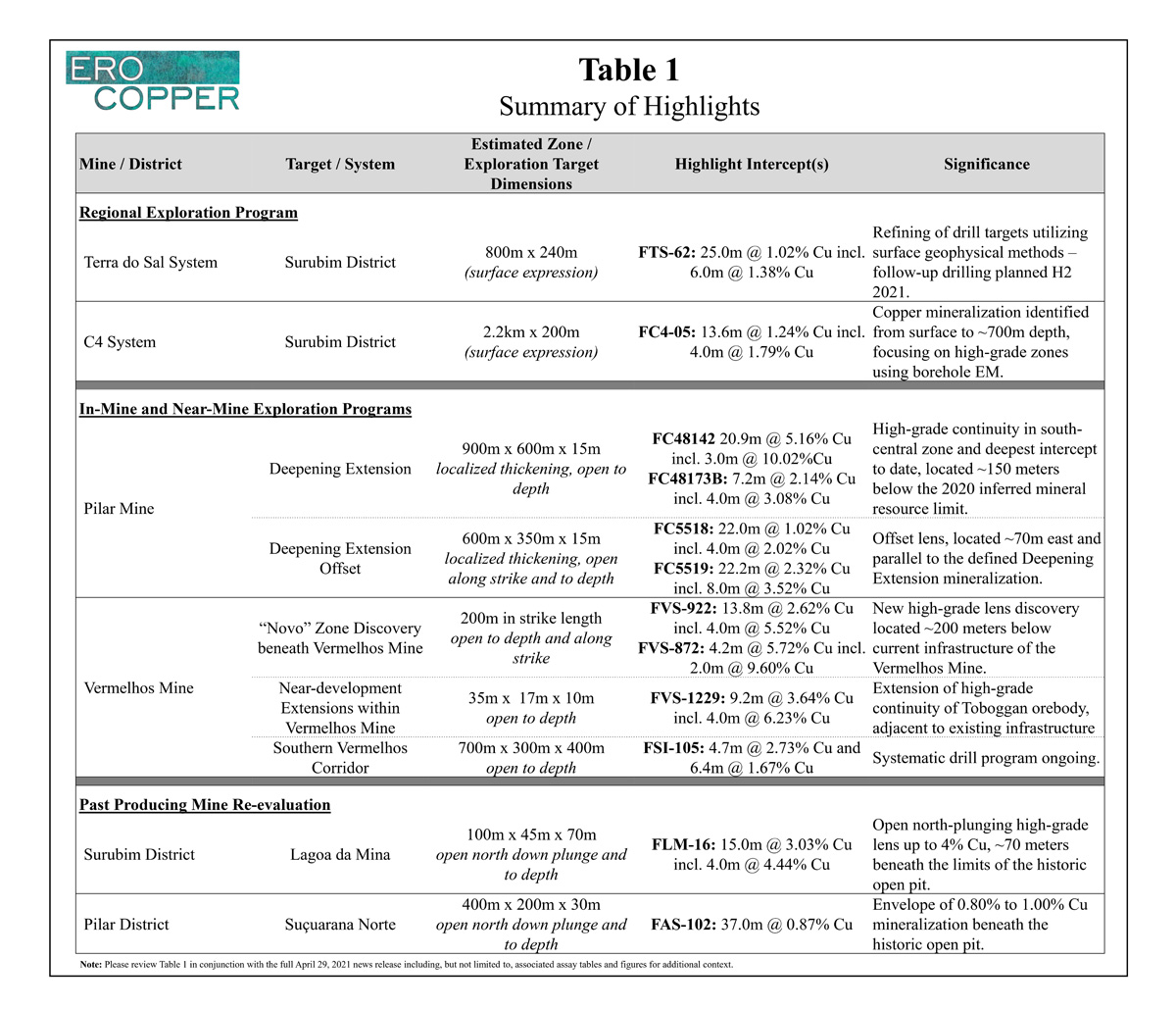
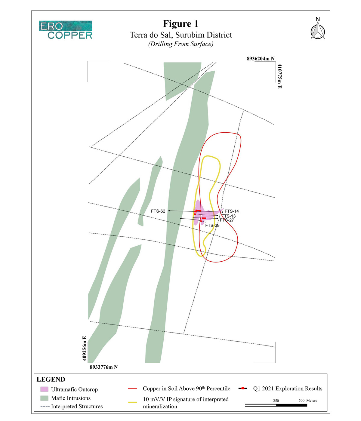
Terra do Sal System
The Terra do Sal System is located 8.0 kilometers southeast of the Surubim Mine. While a small, historic, inferred mineral resource had previously been defined, the incorporation of newly compiled regional datasets, including ground geochemistry and geophysical data, as well as ongoing confirmatory drilling suggests that the mineralized system is more extensive than previously thought. The system footprint has now been interpreted on surface as extending over 800 meters in strike length and measures approximately 250 meters in thickness at surface. Representative historic holes within the Terra do Sal system include FTS-13 that intersected 21.0 meters grading 1.08% copper, FTS-14 that intersected 58.0 meters grading 1.52% copper including 28.0 meters grading 2.05% copper and FTS-27 that intersected 45.0 meters grading 1.01% copper including 16.0 meters grading 1.25% copper. New holes, drilled by the Company in late 2020, demonstrate both the extension of and continuity within the broader system. Results are highlighted by hole FTS-62 that intersected 25.0 meters grading 1.02% including 6.0 meters grading 1.38% copper. Ground geophysical work and target refinement is ongoing with drilling / borehole EM work to further test the broader system expected to recommence later in 2021.
Please see Figure 1 for a plan map detailing Terra do Sal System collar locations and Figure 2 for a east-west cross-section.
| Hole ID | From (m) | To (m) | Length (m) | Cu (%) |
|---|---|---|---|---|
| Terra do Sal System | ||||
| FTS-13 | 325.0 | 346.0 | 21.0 | 1.08 |
| FTS-14 | 243.0 | 301.0 | 58.0 | 1.52 |
| including | 248.0 | 276.0 | 28.0 | 2.05 |
| FTS-27 | 175.0 | 220.0 | 45.0 | 1.01 |
| including | 181.0 | 197.0 | 16.0 | 1.25 |
| FTS-29 | 276.0 | 287.0 | 11.0 | 0.85 |
| FTS-62 | 316.5 | 341.5 | 25.0 | 1.02 |
| including | 326.5 | 332.5 | 6.0 | 1.38 |
NSI indicates no significant intercept, based on a three meter mining width and a cut-off grade of 0.18% copper for regional exploration programs to demonstrate geological controls, irrespective of depth. Drill holes were drilled from surface. Holes not included are either pending assay results, have been included in a different section of this press release for clarity of discussing drill results or were previously included in a prior press release. The length of intercept may not represent the true width of mineralization. Values may not add up due to rounding. From, to and mineralized intercepts are rounded to the nearest tenth of a meter.
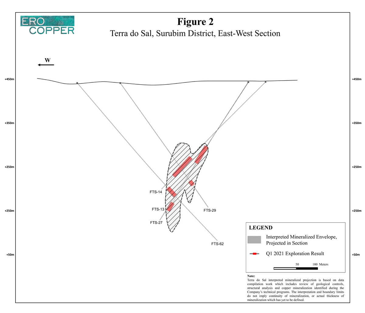
C4 System
The C4 System is located approximately 13 kilometers south, south-west of the Surubim Mine. Drilling and surface geochemistry have estimated the extent of the system on surface over 2.2 kilometers in strike length, and the system has been mapped over approximately 200 meters in thickness at surface. Due to the large footprint of the system, drill targets have been separated into four separate domains. Drill results continue to highlight the extent of disseminated copper mineralization across multiple drill targets within these domains. To date, mineralization has been intercepted at C4 from outcrop at surface to approximately 700 meters below surface as evidenced by hole FC4-01 that intersected a series of mineralized lenses over the length of the 700 meter drill hole – making it among the deepest mineralized intercepts identified in the Curaçá Valley outside of the Pilar Mine. Borehole EM work to target high-grade zones within the identified mineralized target domains remains ongoing.
Please see Figure 3 for a plan map detailing C4 System collar locations and Figure 4 for a north-south long section.
| Hole ID | From (m) | To (m) | Length (m) | Cu (%) |
|---|---|---|---|---|
| C4 System (North) | ||||
| FC4-01* | 47.2 | 50.7 | 3.6 | 0.69 |
| and | 89.8 | 108.5 | 18.8 | 0.31 |
| and | 122.4 | 140.3 | 18.0 | 0.30 |
| and | 161.1 | 205.1 | 44.0 | 0.33 |
| and | 232.9 | 242.7 | 9.8 | 0.31 |
| and | 248.7 | 259.9 | 11.3 | 0.20 |
| and | 265.0 | 270.3 | 5.3 | 0.56 |
| and | 326.8 | 331.8 | 5.0 | 0.38 |
| and | 344.8 | 359.6 | 14.9 | 0.22 |
| and | 390.8 | 400.9 | 10.0 | 0.39 |
| and | 408.2 | 428.7 | 20.4 | 0.22 |
| and | 442.6 | 454.2 | 11.6 | 0.29 |
| and | 472.9 | 507.7 | 34.9 | 0.22 |
| and | 516.7 | 524.5 | 7.8 | 0.33 |
| and | 560.3 | 573.1 | 12.8 | 0.22 |
| and | 589.2 | 614.0 | 24.8 | 0.28 |
| and | 621.3 | 645.5 | 24.2 | 0.22 |
| and | 670.5 | 696.9 | 26.4 | 0.25 |
| FC4-02 | 94.9 | 105.6 | 10.7 | 0.33 |
| and | 111.0 | 122.0 | 11.0 | 0.25 |
| and | 130.3 | 135.1 | 4.8 | 0.45 |
| and | 155.4 | 191.3 | 35.9 | 0.37 |
| including | 174.2 | 187.0 | 12.9 | 0.49 |
| FC4-03 | NSI | NSI | NSI | NSI |
| FC4-07 | 2.2 | 5.7 | 3.5 | 0.48 |
| and | 34.7 | 48.8 | 14.1 | 0.29 |
| and | 72.3 | 77.7 | 5.4 | 0.28 |
| and | 91.8 | 143.5 | 51.7 | 0.24 |
| FC4-10 | NSI | NSI | NSI | NSI |
| FC4-14 | 26.2 | 31.1 | 4.9 | 0.40 |
| and | 65.9 | 72.7 | 6.9 | 0.31 |
| and | 148.7 | 155.1 | 6.4 | 0.44 |
| and | 169.9 | 173.0 | 3.1 | 0.65 |
| CRC4-01 | 70.0 | 80.0 | 10.0 | 0.29 |
| and | 132.0 | 147.0 | 15.0 | 0.28 |
| and | 163.0 | 171.0 | 8.0 | 0.35 |
| and | 186.0 | 200.0 | 14.0 | 0.28 |
| CRC4-02 | 68.0 | 114.0 | 46.0 | 0.21 |
| CRC4-03 | 104.0 | 142.0 | 38.0 | 0.20 |
| and | 158.0 | 213.0 | 55.0 | 0.37 |
| including | 188.0 | 195.0 | 7.0 | 0.89 |
| CRC4-04 | 98.0 | 139.0 | 41.0 | 0.31 |
| and | 178.0 | 185.0 | 7.0 | 0.25 |
| and | 266.0 | 271.0 | 5.0 | 0.64 |
| FC4-17 | NSI | NSI | NSI | NSI |
| C4 System (Central) | ||||
| CRC4-09 | 69.0 | 139.0 | 70.0 | 0.31 |
| including | 90.0 | 106.0 | 16.0 | 0.45 |
| FC4-19 | 24.3 | 75.0 | 50.7 | 0.40 |
| FC4-21 | NSI | NSI | NSI | NSI |
| FC4-25 | 137.2 | 151.2 | 14.0 | 0.32 |
| and | 166.3 | 181.9 | 15.6 | 0.34 |
| FC4-26 | 79.9 | 94.5 | 14.6 | 0.28 |
| and | 101.9 | 150.7 | 48.8 | 0.26 |
| and | 157.3 | 166.8 | 9.5 | 0.21 |
| CRC4-11 | 148.0 | 155.0 | 7.0 | 0.31 |
| and | 162.0 | 168.0 | 6.0 | 0.24 |
| and | 249.0 | 260.0 | 11.0 | 0.52 |
| and | 296.0 | 300.0 | 4.0 | 0.50 |
| FC4-20 | 16.4 | 21.2 | 4.8 | 0.39 |
| and | 40.3 | 92.6 | 52.3 | 0.32 |
| including | 86.0 | 90.0 | 4.0 | 0.69 |
| C4 System (Southeast) | ||||
| FC4-04 | 25.8 | 30.8 | 5.0 | 0.19 |
| and | 37.9 | 46.6 | 8.7 | 0.22 |
| and | 51.5 | 56.7 | 5.2 | 0.22 |
| and | 102.0 | 117.0 | 15.0 | 0.30 |
| FC4-06 | 25.3 | 60.0 | 34.8 | 0.19 |
| FC4-08 | NSI | NSI | NSI | NSI |
| C4 System (Southwest) | ||||
| FC4-05 | 32.8 | 46.4 | 13.6 | 1.24 |
| including | 32.8 | 36.8 | 4.0 | 1.79 |
| FC4-09 | 85.1 | 89.2 | 4.1 | 0.72 |
| FC4-12 | 9.8 | 27.0 | 17.2 | 0.40 |
| and | 42.4 | 51.1 | 8.7 | 0.40 |
| FC4-15 | NSI | NSI | NSI | NSI |
| FC4-18 | NSI | NSI | NSI | NSI |
(*)FC4-01 is a vertical hole, drilled to test mineralization continuity at depth. Please refer to associated long-section for grade profile of drill holes. NSI indicates no significant intercept, based on a three meter mining width and a cut-off grade of 0.18% copper for regional exploration programs to demonstrate geological controls, irrespective of depth. Drill holes were drilled from surface. Holes not included are either pending assay results, have been included in a different section of this press release for clarity of discussing drill results or were previously included in a prior press release. The length of intercept may not represent the true width of mineralization. Values may not add up due to rounding. From, to and mineralized intercepts are rounded to the nearest tenth of a meter.
IN-MINE & NEAR-MINE EXPLORATION PROGRAMS
During the period, the Company continued to prioritize drilling of the Deepening Extension Zone within the Pilar underground mine, where the Company continues to confirm thick and high-grade mineralization at depth as well as extensions of the Vermelhos Mine, including within the Southern Vermelhos Corridor.
The Deepening Extension Zone, Pilar Mine
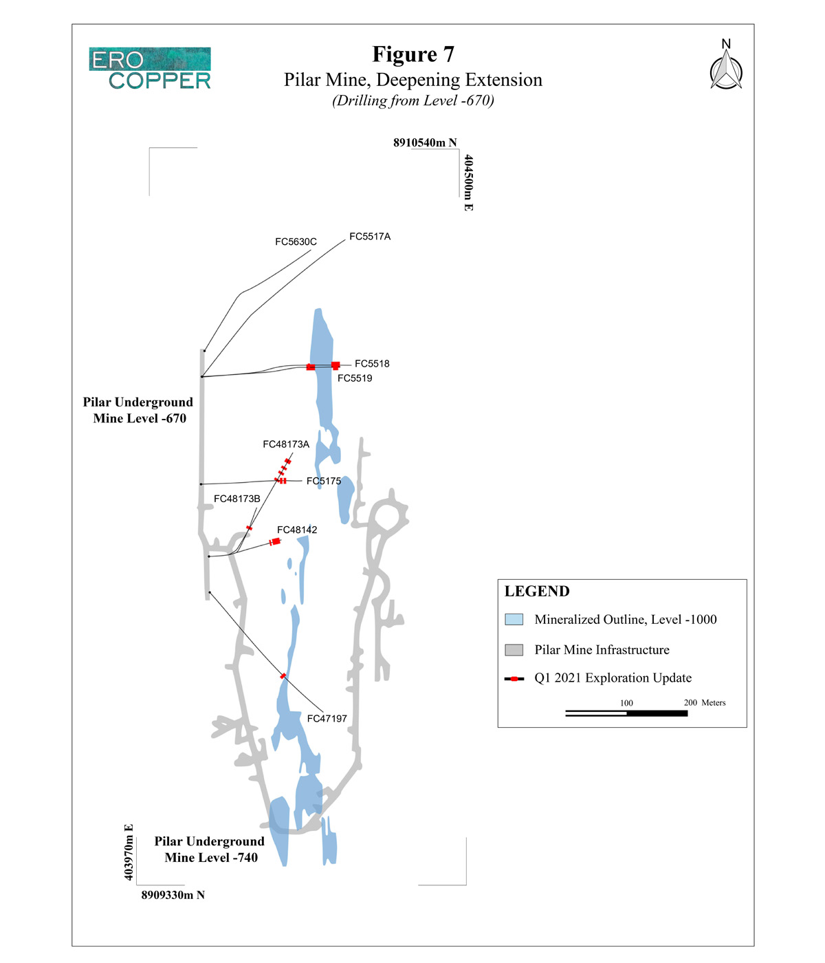
Exploration activities in the Deepening Extension Zone remain focused on upgrading the inferred mineral resource classification through infill drilling and further extending the known limits of mineralization to depth and down-plunge. The drill program utilizing directional drilling technology to evaluate the mineralized potential of the Deepening Extension Zone to depth, continues as planned. These holes can be differentiated by the letter ascribed to the same numerical “parent” hole.
Deepening Extension Zone drilling is currently targeting mineralization on the East Limb of the Pilar Mine to level -1500 approximately 1,200 meters to 2,000 meters below surface and approximately 100 meters laterally from the current level of the primary ramp (completed to level -979).
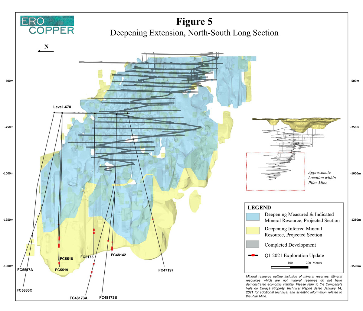
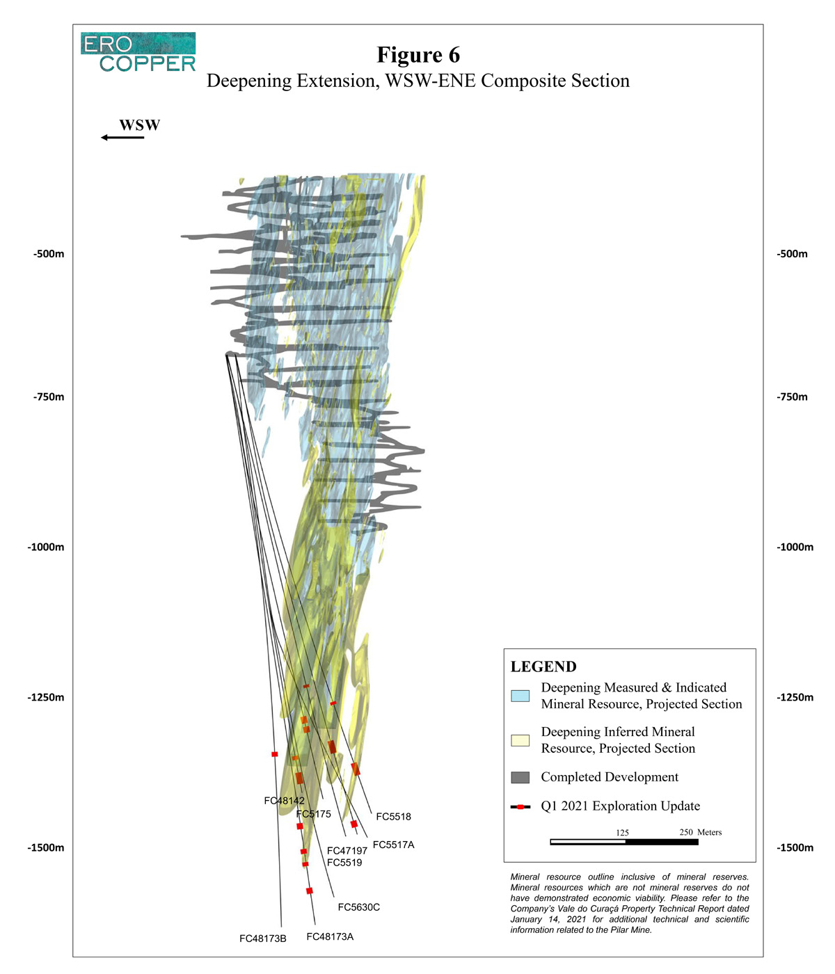
The known limits of mineralization, that remain open, within the Deepening Extension Zone extend over approximately 900 meters in strike length, over a total depth of approximately 600 meters and over average thicknesses ranging from 10 to 15 meters with localized thickening throughout the zone. Within the total strike length, a higher-grade continuous zone of approximately 400 to 500 meters in strike length continues to be supported in the central segments of the target area. Drilling during the period continued to test continuity within a new zone of high-grade mineralization in the south-central segment of this area at depth. Five drill rigs continue to systematically drill the defined exploration target area within the Deepening Extension Zone.
Results are highlighted by noteworthy high-grade drilling throughout the zone including hole FC48142 that intersected 20.9 meters grading 5.16% copper including 3.0 meters grading 10.02% copper within the south-central high-grade area, and hole FC5175 that intersected 11.3 meters grading 4.25% copper including 2.3 meters grading 17.70% copper and 9.7 meters grading 3.15% copper in the northern high-grade area. Results during the period also include the deepest known intercept of mineralization of the Pilar Mine in hole FC48173B, that intersected 7.2 meters grading 2.14% copper including 4.0 meters grading 3.08% copper. The intercept in hole FC48173B is located approximately 200 meters deeper than the limit of the 2020 inferred mineral resource, indicating that the Pilar Mine remains open to depth.
In addition, as was first detailed in the Company’s press release dated December 15, 2020, a new offset zone of parallel mineralization at depth continues to be confirmed. This zone is located approximately 70 to 120 meters east of the main Deepening Extension Zone. Results during the period are highlighted by hole FC5518 that intersected 22.0 meters grading 1.02% copper including 4.0 meters grading 2.02% copper and hole FC5519 that intersected 22.2 meters grading 2.32% copper including 8.0 meters grading 3.52% copper. These holes are located approximately 500 meters north of previously announced hole FC47173 (7.2 meters grading 3.28% copper including 3.0 meters grading 4.35% copper). These new results continue to support the potential to delineate a new, parallel structure to the Deepening Extension Zone extending over a defined north-south strike length of approximately 600 meters that remains open to the north, south and to depth. Please refer to the Company’s press release dated December 15, 2020 for additional detail on previously released holes.
Please see Figure 5 for a north-south long section, Figure 6 for a west-southwest to east-northeast composite section and Figure 7 for a level map showing collar locations of Deepening Extension Zone drilling within the Pilar Mine.
| Hole ID | From (m) | To (m) | Length (m) | Cu (%) |
|---|---|---|---|---|
| Deepening Extension Zone | ||||
| FC47197 | 597.3 | 600.3 | 3.0 | 1.26 |
| FC48142 | 699.9 | 703.9 | 4.0 | 1.11 |
| and | 727.4 | 748.3 | 20.9 | 5.16 |
| including | 738.9 | 741.9 | 3.0 | 10.02 |
| FC48173A | 526.2 | 534.8 | 8.6 | 0.85 |
| and | 539.8 | 566.3 | 26.6 | 1.53 |
| including | 539.8 | 552.8 | 13.0 | 2.15 |
| and | 573.2 | 580.2 | 7.0 | 2.21 |
| including | 573.2 | 575.2 | 2.0 | 5.26 |
| and | 597.3 | 600.4 | 3.1 | 1.82 |
| and | 642.9 | 651.5 | 8.6 | 2.10 |
| FC48173B | 360.1 | 367.3 | 7.2 | 2.14 |
| including | 362.1 | 366.1 | 4.0 | 3.08 |
| FC5175 | 638.1 | 649.3 | 11.3 | 4.25 |
| including | 638.1 | 640.3 | 2.3 | 17.70 |
| and | 656.3 | 666.1 | 9.7 | 3.15 |
| including | 663.8 | 666.1 | 2.2 | 11.18 |
| FC5517A | NSI | NSI | NSI | NSI |
| FC5518 | 628.6 | 631.6 | 3.1 | 1.07 |
| and | 739.0 | 761.0 | 22.0 | 1.02 |
| including | 740.0 | 744.0 | 4.0 | 2.02 |
| FC5519 | 691.5 | 713.7 | 22.2 | 2.32 |
| including | 702.3 | 710.3 | 8.0 | 3.52 |
| and | 835.6 | 847.6 | 12.0 | 1.36 |
| including | 845.6 | 847.6 | 2.0 | 3.66 |
| FC5630C | NSI | NSI | NSI | NSI |
NSI indicates no significant intercept based on a three meter mining width and cut-off grade of 0.51% copper. Drill holes were drilled from level -670 in the Pilar Mine. Holes not included are either pending assay results, have been included in a different section of this press release for clarity of discussing drill results or were previously included in a prior press release. The length of intercept may not represent the true width of mineralization. Values may not add up due to rounding. From, to and mineralized intercepts are rounded to the nearest tenth of a meter.
Vermelhos Mine Extensions
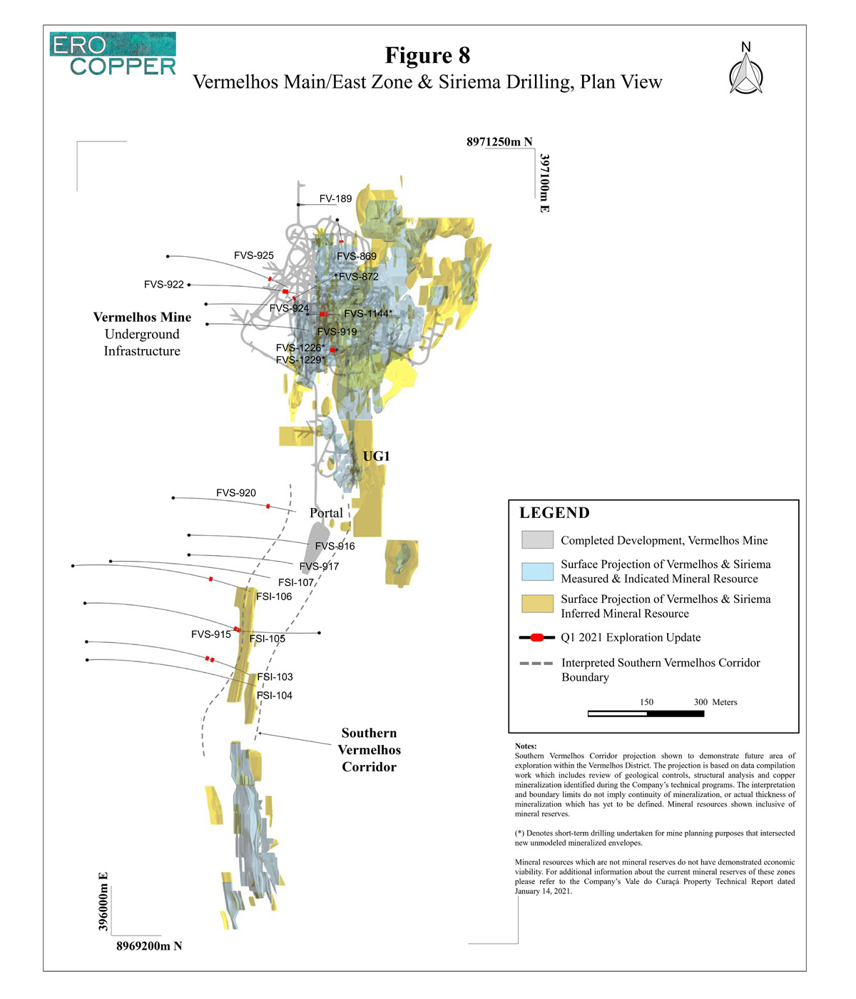
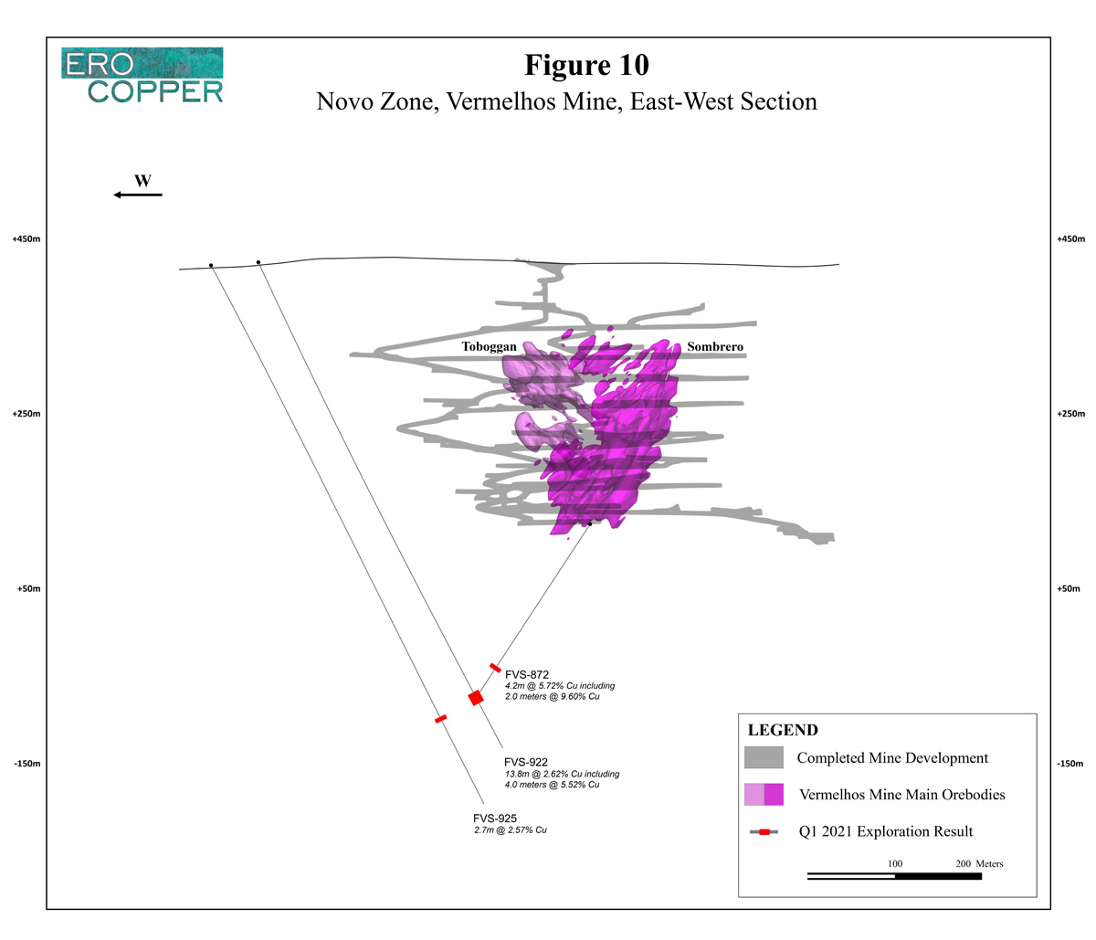
Within the Vermelhos Mine, drilling seeks to test continuity of mineralization near existing mine infrastructure and to test for new high-grade lenses at depth. Results are highlighted by hole FVS-922 that intersected 13.8 meters grading 2.62% copper including 4.0 meters grading 5.52% copper and hole FVS-872 that intersected 4.2 meters grading 5.72% copper including 2.0 meters grading 9.60% copper in a newly discovered zone of mineralization. The zone, known as the “Novo Zone” was drilled based upon a revised structural interpretation supported by geologic mapping of the main Vermelhos orebodies. The new discovery is located approximately 200 meters below the existing infrastructure of the Vermelhos Mine and has been interpreted as a sub-horizontal, north-plunging lens of high-grade massive sulphide mineralization, extending over an identified strike length to date of approximately 200 meters. The lens remains open down plunge and drilling of the modeled extension, along with borehole EM surveys, is ongoing.
In addition to the Novo Zone, new mineralization extending the continuity of high-grade mineralization adjacent to existing infrastructure within the mine has been delineated during short-term infill drilling. A new area of mineralization identified within the immediate mine area extends known high-grade mineralization and remains open to depth. The target area has been drilled over 35 meters in strike length, 17 meters in vertical extent with an average thickness of 10 meters, and is located immediately adjacent to existing infrastructure.
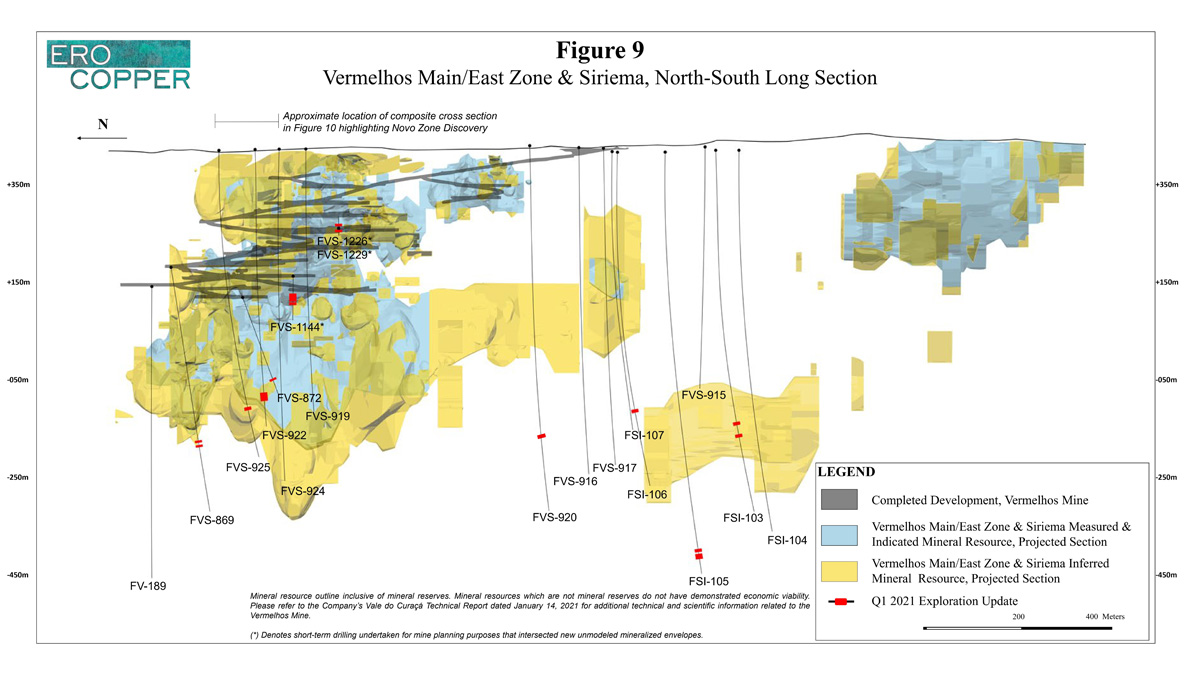
Please see Figure 8 for a plan map detailing all Vermelhos near-mine collar locations, Figure 9 for north-south long section detailing all Vermelhos near-mine drilling and Figure 10 for an east-west cross-section detailing the Novo Zone discovery.
| Hole ID | From (m) | To (m) | Length (m) | Cu (%) |
|---|---|---|---|---|
| Vermelhos Mine Toboggan Extension | ||||
| FV-189 | NSI | NSI | NSI | NSI |
| FVS-869 | 357.0 | 360.0 | 3.0 | 0.86 |
| and | 366.0 | 370.0 | 4.0 | 1.03 |
| FVS-919 | NSI | NSI | NSI | NSI |
| FVS-1144* | 51.5 | 64.3 | 12.8 | 1.77 |
| including | 61.6 | 64.3 | 2.7 | 3.59 |
| and | 69.3 | 76.5 | 7.2 | 2.35 |
| FVS-1226* | 8.2 | 12.0 | 3.7 | 4.74 |
| FVS-1229* | 7.3 | 16.5 | 9.2 | 3.64 |
| including | 11.5 | 15.5 | 4.0 | 6.23 |
| Novo Zone | ||||
| FVS-872 | 205.0 | 209.2 | 4.2 | 5.72 |
| including | 207.2 | 209.2 | 2.0 | 9.60 |
| FVS-922 | 553.8 | 567.5 | 13.8 | 2.62 |
| including | 562.9 | 566.9 | 4.0 | 5.52 |
| FVS-924 | NSI | NSI | NSI | NSI |
| FVS-925 | 588.7 | 591.4 | 2.7 | 2.57 |
NSI indicates no significant intercept, based on a three meter mining width and a cut-off grade of 0.18% copper for near-surface intervals and 0.51% for intervals below 200 meters down hole. Drill holes were drilled from surface and from level +258, level +170, level +190 and level +120 in the Vermelhos Mine. Holes not included are either pending assay results, have been included in a different section of this press release for clarity of discussing drill results or were previously included in a prior press release. The length of intercept may not represent the true width of mineralization. Values may not add up due to rounding. From, to and mineralized intercepts are rounded to the nearest tenth of a meter. (*) Denotes short-term drilling undertaken for mine planning purposes that intersected new unmodeled mineralized envelopes.
Southern Vermelhos Corridor
Exploration activities during the period within the Southern Vermelhos Corridor, a near-mine exploration zone extending from the Siriema Deposit to the UG1 mining area of the Vermelhos Mine, remain focused on two primary objectives: (i) testing continuity of high-grade copper mineralization within the corridor, and (ii) conducting borehole EM surveys to identify high-grade exploration targets. The target zone within the Southern Vermelhos Corridor has a north-south strike length of approximately 700 meters, an east-west section width of approximately 300 meters and is currently defined to a depth of approximately 400 meters below surface.
The program continues to demonstrate the presence of multiple stacked mineralized lenses, including high-grade mineralization. Three drill rigs are operational within the Southern Vermelhos Corridor focused on systematically testing the continuity of mineralization. The program has been designed on 50 meter drill spacing. Initially, the focus will be the northern section of the Southern Vermelhos Corridor given its proximity to the existing mine infrastructure of the Vermelhos Mine and the potential for exploration success to meaningfully enhance the near-term base-case grade profile through replacement of lower grade production in addition to extending the mine life of the Vermelhos Mine.
Results during the period are highlighted by hole FSI-105 that intersected 4.7 meters grading 2.73% copper and 6.4 meters grading 1.67% copper. In relation to previous holes, FSI-105 is approximately 60 meters southwest of hole FVS-910 (7.2 meters grading 1.20% copper including 9.1 meters grading 1.83% copper ) and approximately 330 meters southwest of hole FVS-911 (3.1 meters grading 1.21% copper and 5.1 meters grading 1.98% copper). Please refer to the Company’s press release dated December 15, 2020 for additional detail on previously released holes.
Intercepts below three meters in thickness drilled within the Southern Vermelhos Corridor are reported below as not significant, consistent with the Company’s minimum mining thickness and overall approach to reporting exploration drill results.
Please see Figure 8 for a plan map detailing Southern Vermelhos Corridor collar locations and Figure 9 for a north-south long section detailing all Vermelhos near-mine drilling.
| Hole ID | From (m) | To (m) | Length (m) | Cu (%) |
|---|---|---|---|---|
| Southern Vermelhos Corridor | ||||
| FSI-103 | 638.1 | 642.3 | 4.2 | 1.55 |
| and | 666.5 | 671.8 | 5.3 | 1.07 |
| FSI-104 | NSI | NSI | NSI | NSI |
| FSI-105 | 900.6 | 905.3 | 4.7 | 2.73 |
| and | 913.0 | 919.4 | 6.4 | 1.67 |
| FSI-106 | 635.0 | 638.7 | 3.7 | 1.50 |
| FSI-107 | NSI | NSI | NSI | NSI |
| FVS-915 | NSI | NSI | NSI | NSI |
| FVS-916 | NSI | NSI | NSI | NSI |
| FVS-917 | NSI | NSI | NSI | NSI |
NSI indicates no significant intercept based on a three meter mining width and cut-off grade of 0.51% copper. Drill holes were drilled from surface. Holes not included are either pending assay results, have been included in a different section of this press release for clarity of discussing drill results or were previously included in a prior press release. The length of intercept may not represent the true width of mineralization. Values may not add up due to rounding. From, to and mineralized intercepts are rounded to the nearest tenth of a meter.
PAST PRODUCING MINE RE-EVALUATION
In late 2020, the Company commenced an exploration program designed to strategically review and re-evaluate known zones of mineralization existing beneath fully permitted past producing open pit mines throughout the Curaçá Valley. This program sought to utilize and incorporate new datasets developed during the Company’s regional exploration programs to isolate and extend high-grade mineralized envelopes beneath the mines suitable for open pit and underground mine development and/or implementation of ore-sorting. The preliminary results of this program are positive and the Company expects that, with continued exploration success, these new zones may form an integral component of the Company’s near to medium-term growth objectives in terms of filling excess mill capacity at elevated grade profiles. Examples of identified targets zones within the Lagoa da Mina and Suçuarana open pits are provided below.
Lagoa da Mina, Angicos Mine, Surubim District
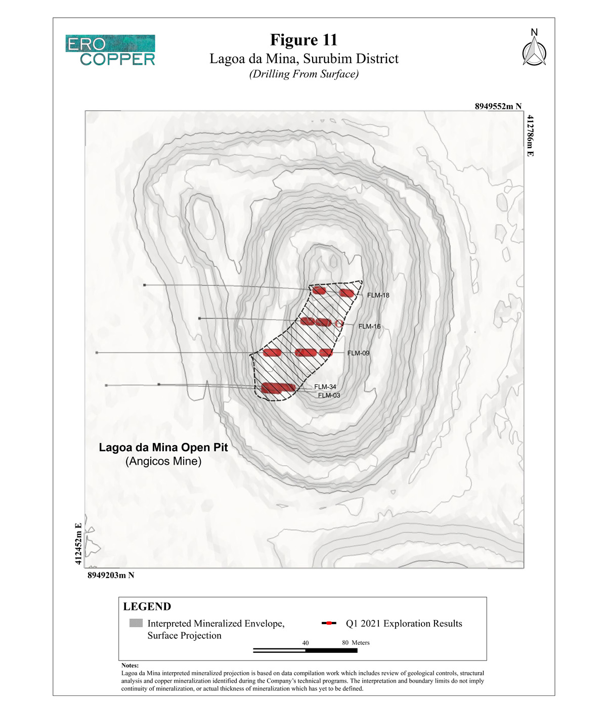
The past producing open pit Angicos Mine, within the Surubim District, is located approximately 11 kilometers northeast of the Surubim Open Pit Mine and approximately 32 kilometers north of the Pilar Mine. While the aggregate mineral resource of the Angicos Mine is considered to be primarily lower-grade disseminated copper sulphide mineralization, the Company’s work program has identified a high-grade zone within the overall mineralized envelope of the mineral resource that remains open along strike and to depth. To date, the interpreted high-grade lens can be traced over 100 meters in strike length, 45 meters in width with variable thickness of up to 70 meters down-dip. The characteristic nature of this high-grade lens is best highlighted by previously drilled hole, FLM-16, that intersected 15.0 meters grading 3.03% copper including 4.0 meters grading 4.44% copper. To demonstrate additional continuity of the modeled zone, drilling of this area commenced in late Q1 2021 along with borehole EM surveys. Results from this new drill campaign are expected during the Company’s second quarter exploration update. The table below highlights the historic drill holes that define the newly interpreted high grade lens.
Please see Figure 11 for a plan map detailing Lago da Mina collar locations and Figure 12 for a north-south long section.
| Hole ID | From (m) | To (m) | Length (m) | Cu (%) |
|---|---|---|---|---|
| Lagoa da Mina | ||||
| FLM-03 | 200.0 | 220.0 | 20.0 | 1.16 |
| FLM-09 | 180.0 | 194.0 | 14.0 | 0.82 |
| and | 214.0 | 232.0 | 18.0 | 1.09 |
| and | 240.0 | 249.0 | 9.0 | 1.27 |
| FLM-16 | 155.0 | 168.0 | 13.0 | 1.13 |
| including | 165.0 | 168.0 | 3.0 | 2.56 |
| and | 178.0 | 193.0 | 15.0 | 3.03 |
| including | 189.0 | 193.0 | 4.0 | 4.44 |
| and | 208.0 | 211.0 | 3.0 | 1.01 |
| FLM-18 | 194.0 | 203.0 | 9.0 | 1.28 |
| including | 194.0 | 196.0 | 2.0 | 2.08 |
| and | 224.0 | 235.0 | 11.0 | 1.59 |
| including | 225.0 | 227.0 | 2.0 | 2.08 |
| FLM-34 | 160.0 | 203.0 | 43.0 | 1.00 |
NSI indicates no significant intercept, based on a three meter mining width and a cut-off grade of 0.18% copper for regional exploration programs to demonstrate geological controls, irrespective of depth. Drill holes were drilled from surface. Holes not included are either pending assay results, have been included in a different section of this press release for clarity of discussing drill results or were previously included in a prior press release. The length of intercept may not represent the true width of mineralization. Values may not add up due to rounding. From, to and mineralized intercepts are rounded to the nearest tenth of a meter.
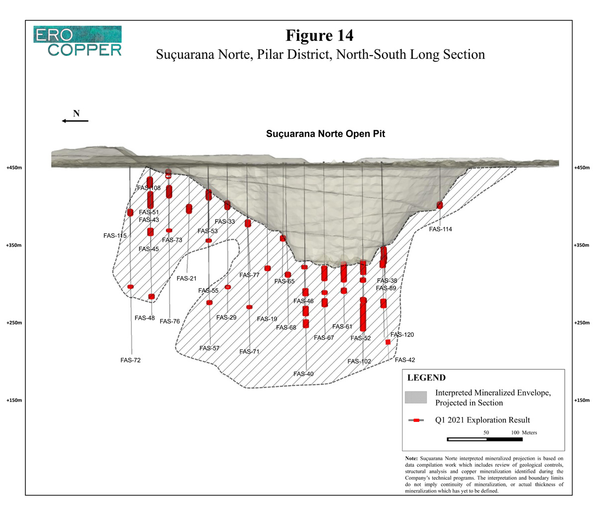
Suçuarana Norte, Suçuarana Mine, Pilar District
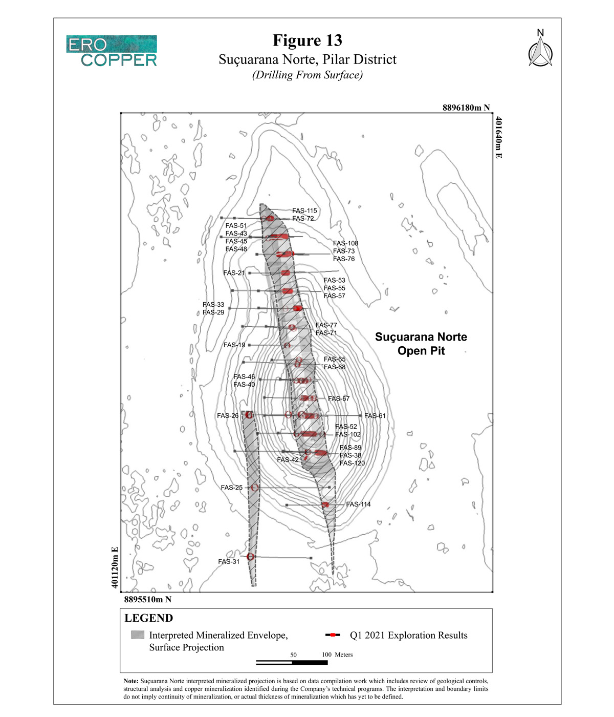
The past producing open pit mine of Suçuarana Norte, within the Pilar District, is located approximately 20 kilometers south of the Pilar Mine and Caraíba Mill. The strategic review of the Suçuarana Norte open pit, similar to Lagoa da Mina, has identified a continuous zone of mineralization, grading between 0.60% and 1.00% copper extending from just beneath the historic open pit mine over 400 meters in strike length. To date, the higher-grade zone has been modeled to a depth approximately 200 meters from the bottom of the open pit and measures up to 30 meters in thickness. The zone is believed to be comprised of two parallel, primary sub-vertical mineralized structures, which are known as the East and West Lens. To demonstrate additional continuity of the modeled zone, drilling of this area commenced in late Q1 2021 along with borehole EM surveys. Results from this new drill campaign are expected during the Company’s second quarter exploration update. The table below highlights the historic drill holes that define the newly interpreted higher grade lenses.
Please see Figure 13 for a plan map detailing Suçuarana Norte collar locations and Figure 14 for a north-south long section.
| Hole ID | From (m) | To (m) | Length (m) | Cu (%) |
|---|---|---|---|---|
| Suçuarana Norte, West Lens | ||||
| FAS-25 | 241.0 | 245.0 | 4.0 | 0.77 |
| FAS-26 | 155.0 | 161.0 | 6.0 | 0.72 |
| and | 192.0 | 195.0 | 3.0 | 0.80 |
| and | 296.0 | 303.0 | 7.0 | 0.65 |
| FAS-31 | 163.0 | 168.0 | 5.0 | 0.87 |
| Suçuarana Norte, East Lens | ||||
| FAS-19 | 142.0 | 147.0 | 5.0 | 0.75 |
| FAS-21 | 70.0 | 81.0 | 11.0 | 0.84 |
| FAS-29 | 174.0 | 177.0 | 3.0 | 0.72 |
| FAS-33 | 70.0 | 81.0 | 11.0 | 0.73 |
| FAS-38 | 121.0 | 138.0 | 17.0 | 0.96 |
| FAS-40 | 170.0 | 179.0 | 9.0 | 0.86 |
| and | 194.0 | 206.0 | 12.0 | 0.82 |
| and | 212.0 | 222.0 | 10.0 | 0.70 |
| FAS-42 | 118.0 | 121.0 | 3.0 | 0.81 |
| and | 233.0 | 237.0 | 4.0 | 0.80 |
| FAS-43 | 47.0 | 72.0 | 25.0 | 0.87 |
| FAS-45 | 87.0 | 96.0 | 9.0 | 0.92 |
| FAS-46 | 138.0 | 142.0 | 4.0 | 0.87 |
| FAS-48 | 179.0 | 184.0 | 5.0 | 0.76 |
| FAS-51 | 22.0 | 36.0 | 14.0 | 0.88 |
| FAS-52 | 134.0 | 153.0 | 19.0 | 0.96 |
| and | 186.0 | 192.0 | 6.0 | 1.02 |
| FAS-53 | 49.0 | 63.0 | 14.0 | 0.94 |
| FAS-55 | 104.0 | 107.0 | 3.0 | 0.82 |
| FAS-57 | 189.0 | 193.0 | 4.0 | 0.72 |
| FAS-61 | 141.0 | 168.0 | 27.0 | 0.81 |
| and | 178.0 | 184.0 | 6.0 | 0.89 |
| FAS-65 | 101.0 | 107.0 | 6.0 | 0.87 |
| FAS-67 | 144.0 | 163.0 | 19.0 | 0.98 |
| and | 178.0 | 182.0 | 4.0 | 0.70 |
| and | 189.0 | 199.0 | 10.0 | 0.77 |
| FAS-68 | 160.0 | 165.0 | 5.0 | 0.94 |
| FAS-71 | 196.0 | 199.0 | 3.0 | 0.75 |
| FAS-72 | 166.0 | 169.0 | 3.0 | 0.97 |
| FAS-73 | 41.0 | 59.0 | 18.0 | 0.95 |
| FAS-76 | 88.0 | 91.0 | 3.0 | 0.87 |
| FAS-77 | 81.0 | 89.0 | 8.0 | 0.74 |
| FAS-89 | 166.0 | 177.0 | 11.0 | 0.89 |
| FAS-102 | 158.0 | 163.0 | 5.0 | 1.04 |
| and | 185.0 | 190.0 | 5.0 | 0.76 |
| and | 193.0 | 230.0 | 37.0 | 0.87 |
| FAS-108 | 7.0 | 12.0 | 5.0 | 0.76 |
| and | 15.0 | 18.0 | 3.0 | 0.86 |
| FAS-114 | 73.1 | 80.1 | 7.0 | 1.03 |
| FAS-115 | 74.6 | 81.6 | 7.0 | 0.81 |
| FAS-120 | 130.2 | 139.0 | 8.75 | 0.82 |
| and | 181.8 | 192.8 | 11.0 | 0.72 |
| and | 193.0 | 230.0 | 37.0 | 0.87 |
NSI indicates no significant intercept, based on a three meter mining width and a cut-off grade of 0.18% copper for regional exploration programs to demonstrate geological controls, irrespective of depth. Drill holes were drilled from surface. Holes not included are either pending assay results, have been included in a different section of this press release for clarity of discussing drill results or were previously included in a prior press release. The length of intercept may not represent the true width of mineralization. Values may not add up due to rounding. From, to and mineralized intercepts are rounded to the nearest tenth of a meter.
NOTE ON NI 43-101 COMPLIANT TECHNICAL REPORT(S)
The conversion of drill results presented in this press release into NI 43-101 compliant mineral resources and mineral reserves, including but not limited to the drill results associated with the new and potential extensions of mineralization across each of the mineral districts, including new discoveries and newly identified mineralized systems outlined in this press release, all require additional work and analysis that remains ongoing. To date, there has been insufficient exploration and accompanying analysis to define a mineral resource and it is uncertain if further exploration will result in these extensions being delineated as a mineral resource. Accordingly, the results herein may not be included in future NI 43-101 compliant mineral resources or mineral reserves depending on the results of this additional work and analysis, and other technical and/or economic reasons.
QUALITY ASSURANCE / QUALITY CONTROL
MCSA Mining Complex
The Company is currently drilling on surface and underground with core drill rigs using a combination of owned and third-party contracted drill rigs. During the period from November 2020 through early April 2021, third-party drill rigs were operated by Major Drilling do Brasil Ltda., Tamarama Sondagens Ltda., Layne Christensen Co., and DrillGeo Geologia e Sondagem Ltda., all of whom are independent of the Company. Drill core is logged, photographed and split in half using a diamond core saw at the secure core logging and storage facilities of Mineração Caraíba S.A. (“MCSA”). Half of the drill core is retained on site and the other half core is used for analysis, with samples collected on one-meter sample intervals unless an interval crosses a geological contact. Reverse circulation cuttings are split at the drill rig using one-meter sample intervals. All sample preparation is performed in MCSA’s secure on-site laboratory. Total copper is determined using a nitric-hydrochloric acid digestion and Atomic Absorption Spectrometry (“AAS”) and/or Titration. Oxide copper values are determined using sulfuric acid digestion followed by AAS. PGM and gold analysis during the period was performed at the SGS S.A.’s facility in Rustenburg, South Africa and Mintek S.A.’s facility in Johannesburg, South Africa, with values determined using nickel sulphide and lead collection fire assay. SGS S.A. and Mintek S.A. are independent of the Company. All sample results during the period have been monitored through a QA/QC program that includes the insertion of certified standards, blanks, and pulp and reject duplicate samples. Regular check-assays are submitted to ALS Brasil Ltda’s facility located in Vespasiano, Minas Gerais, Brazil, at a rate of approximately 5%. ALS Brasil Ltda is a subsidiary of ALS Limited and is independent of the Company.
NX Gold Mine
The Company is currently drilling on surface with third-party contracted core drill rigs. During the period from November 2020 through early April 2021 third-party drill rigs were operated by Servitec Foraco Sondagem S.A. who is independent of the Company. Drill core is logged, photographed and split in half using a diamond core saw at NX Gold S.A.’s (“NX Gold”) secure core logging and storage facilities. Half of the drill core is retained on site and the other half core is used for analysis, with samples collected on half-meter sample intervals for quartz vein and one-meter intervals in surrounding rock unless such interval crosses a geological contact. Samples are sent to ALS Brasil Ltda.’s laboratory in Goiânia (Brazil) for preparation and are analyzed by the certified laboratory of ALS Peru S.A., whom are independent of the Company. During the period, gold content has been determined by both fire assay and screen fire assay. All sample results during the period have been monitored through a QA/QC program that includes the insertion of certified standards, blanks, and pulp and reject duplicate samples at a rate of one standard, one blank, and one duplicate pulp sample per every 20 samples for a blended rate of approximately 5%.
Emerson Ricardo Re, MSc, MBA, MAusIMM (CP) (No. 305892), Registered Member (No. 0138) (Chilean Mining Commission) and Resource Manager of the Company who is a “qualified person” within the meanings of NI 43-101, has reviewed and approved the disclosure of technical information, including verification of the sampling, analytical and testing data in this press release. Quarterly reviews entail sampling and laboratory procedure review as well as verification of original assay certificates associated with a selection of samples from Company’s internal database included in this press release.
ABOUT ERO COPPER CORP
Ero, headquartered in Vancouver, B.C., is focused on copper production growth from the MCSA Mining Complex, located in Bahia, Brazil. The Company's primary asset is a 99.6% interest in the Brazilian copper mining company, MCSA, 100% owner of the MCSA Mining Complex with over 40 years of operating history in the region. The Company currently mines copper ore from the Pilar and Vermelhos underground mines. In addition to the MCSA Mining Complex, MCSA owns 100% of the Boa Esperança development project, an IOCG-type copper project located in Pará, Brazil and the Company owns 97.6% of the NX Gold Mine, an operating gold and silver mine located in Mato Grosso, Brazil. Additional information on the Company and its operations, including technical reports on the MCSA Mining Complex, Boa Esperança and NX Gold properties, can be found on the Company's website (www.erocopper.com) and on SEDAR (www.sedar.com).
ERO COPPER CORP. |
|
Signed: “David Strang” | For further information contact: |
David Strang, President & CEO | Makko DeFilippo, Vice President, Corporate Development |
| (604) 429-9244 |
|
CAUTION REGARDING FORWARD LOOKING INFORMATION AND STATEMENTS This press release contains “forward-looking information” within the meaning of applicable Canadian securities laws. Forward-looking information includes statements that use forward-looking terminology such as “may”, “could”, “would”, “will”, “should”, “intend”, “target”, “plan”, “expect”, “budget”, “estimate”, “forecast”, “schedule”, “anticipate”, “believe”, “continue”, “potential”, “view” or the negative or grammatical variation thereof or other variations thereof or comparable terminology. Such forward-looking information includes, without limitation, statements with respect to the Company's expected operations at the MCSA Mining Complex and the NX Gold Mine, the estimation of mineral reserves and mineral resources, the significance of any particular exploration program or result and the Company’s expectations for current and future exploration plans including, but not limited to, planned areas of additional exploration, the potential to convert any portion of the inferred mineral resource base, the significance of any drill results or new discoveries and targets, including without limitation extensions of defined mineralized zones, possibilities for mine life extensions or continuity of down-plunge mineralization, further extensions and expansion of mineralization near the Company’s existing operations of the MCSA Mining Complex or the NX Gold Mine, statements with respect to potential for any additional PGM mineralization in the Curaçá Valley, statements with respect to the importance of any new discoveries including newly identified mineral systems, the significance of re-evaluation of the Company’s past producing open pit mines, timing of deliverables including assay results for the NX Gold Mine or PGM analysis, timing of the Company’s next exploration update as well as any implied significance or continuity therein including with respect to filling excess mill capacity or improving grade profiles relative to the Company’s current life of mine plans, and statements with respect to any potential positive economic enhancements as it relates to the Company’s recent life-of-mine plan(s), or base-case plan(s) for the Deepening Extension Zone of the Pilar Mine, the Vermelhos Mine, any past producing open pit operations of the Company, or the NX Gold Mine based upon exploration drill results.
Forward-looking information is not a guarantee of future performance and is based upon a number of estimates and assumptions of management in light of management’s experience and perception of trends, current conditions and expected developments, as well as other factors that management believes to be relevant and reasonable in the circumstances, as of the date of this Press Release including, without limitation, assumptions about: favourable equity and debt capital markets; the ability to raise any necessary additional capital on reasonable terms to advance the production, development and exploration of the Company’s properties and assets; future prices of copper and other metal prices; the timing and results of exploration and drilling programs; the accuracy of any mineral reserve and mineral resource estimates; the geology of the MCSA Mining Complex, NX Gold Mine and the Boa Esperança Property being as described in the technical reports for these properties; production costs; the accuracy of budgeted exploration and development costs and expenditures; the price of other commodities such as fuel; future currency exchange rates and interest rates; operating conditions being favourable such that the Company is able to operate in a safe, efficient and effective manner; work force continues to remain healthy in the face of prevailing epidemics, pandemics or other health risks, political and regulatory stability; the receipt of governmental, regulatory and third party approvals, licenses and permits on favourable terms; obtaining required renewals for existing approvals, licenses and permits on favourable terms; requirements under applicable laws; sustained labour stability; stability in financial and capital goods markets; availability of equipment and critical supplies, spare parts and consumables; positive relations with local groups and the Company’s ability to meet its obligations under its agreements with such groups; and satisfying the terms and conditions of the Company’s current loan arrangements. While the Company considers these assumptions to be reasonable, the assumptions are inherently subject to significant business, social, economic, political, regulatory, competitive and other risks and uncertainties, contingencies and other factors that could cause actual actions, events, conditions, results, performance or achievements to be materially different from those projected in the forward-looking information. Many assumptions are based on factors and events that are not within the control of the Company and there is no assurance they will prove to be correct.
Furthermore, such forward-looking information involves a variety of known and unknown risks, uncertainties and other factors which may cause the actual plans, intentions, activities, results, performance or achievements of the Company to be materially different from any future plans, intentions, activities, results, performance or achievements expressed or implied by such forward-looking information. Such risks include, without limitation the risk factors listed under the heading “Risk Factors” in the Annual Information Form of the Company for the year ended December 31, 2020, dated March 16, 2021 (the “AIF”).
Although the Company has attempted to identify important factors that could cause actual actions, events, conditions, results, performance or achievements to differ materially from those described in forward-looking information, there may be other factors that cause actions, events, conditions, results, performance or achievements to differ from those anticipated, estimated or intended.
The Company cautions that the foregoing lists of important assumptions and factors are not exhaustive. Other events or circumstances could cause actual results to differ materially from those estimated or projected and expressed in, or implied by, the forward-looking information contained herein. There can be no assurance that forward-looking information will prove to be accurate, as actual results and future events could differ materially from those anticipated in such information. Accordingly, readers should not place undue reliance on forward-looking information.
Forward-looking information contained herein is made as of the date of this press release and the Company disclaims any obligation to update or revise any forward-looking information, whether as a result of new information, future events or results or otherwise, except as and to the extent required by applicable securities laws.
GENERAL Information of a scientific or technical nature in respect of the MCSA Mining Complex included in this press release is based upon the MCSA Mining Complex technical report entitled “2020 Updated Mineral Resources and Mineral Reserves Statements of Mineração Caraíba’s Vale do Curaçá Mineral Assets, Curaçá Valley”, dated January 14, 2021 with an effective date of October 1, 2020, prepared by Porfirio Cabaleiro Rodrigues, FAIG, Bernardo Horta de Cerqueira Viana, MAIG, Paulo Roberto Bergmann, FAusIMM, Fábio Valério Câmara Xavier, MAIG and Dr. Augusto Ferreira Mendonça, RM SME all of GE21 Consultoria Mineral Ltda. (“GE21”) and Dr. Beck (Alizeibek) Nader, FAIG of BNA Mining Solutions (“BNA”), whom are independent qualified persons under NI 43-101. Information of a scientific or technical nature in respect of the NX Gold Mine included in this press release is based upon the technical report entitled Mineral Resource and Mineral Reserve Estimate of the NX Gold Mine, Nova Xavantina”, dated January 8, 2021 with an effective date of September 30, 2020, prepared by Porfirio Cabaleiro Rodrigues, FAIG, Paulo Roberto Bergmann, FAusIMM, Bernardo Horta de Cerqueira Viana, MAIG and Leonardo de Moraes Soares, MAIG, all of GE21, whom are independent qualified persons under NI 43-101.
Please see the relevant Technical Reports filed on the Company’s profile at www.sedar.com, for details regarding the data verification undertaken with respect to the scientific and technical information included in this press release regarding the MCSA Mining Complex and the NX Gold Mine for additional details regarding the related exploration information, including interpretations, the QA/QC employed, sample, analytical and testing results and for additional details regarding the Mineral Resource and Mineral Reserve estimates discussed herein.
Cautionary Notes Regarding Mineral Resource and Reserve Estimates In accordance with applicable Canadian securities regulatory requirements, all mineral reserve and mineral resource estimates of the Company disclosed or incorporated by reference in this press release have been prepared in accordance with NI 43-101 and are classified in accordance with the CIM Standards.
Mineral resources which are not mineral reserves do not have demonstrated economic viability. Pursuant to the CIM Standards, mineral resources have a higher degree of uncertainty than mineral reserves as to their existence as well as their economic and legal feasibility. Inferred mineral resources, when compared with Measured or Indicated mineral resources, have the least certainty as to their existence, and it cannot be assumed that all or any part of an Inferred mineral resource will be upgraded to an Indicated or Measured mineral resource as a result of continued exploration. Pursuant to NI 43-101, Inferred mineral resources may not form the basis of any economic analysis. Accordingly, readers are cautioned not to assume that all or any part of a mineral resource exists, will ever be converted into a mineral reserve, or is or will ever be economically or legally mineable or recovered.